2010-10-09 49 10
| Sat 9 Oct 2010 in 49,10: 49.6427434, 10.8359639 geohashing.info google osm bing/os kml crox |
Location
The hash point is located on a field between villages of Kairlingdach and Mechelwind, about 15km NW from the city of Erlangen.
Participants
Expedition
This was my first geohashing attempt, and luckily it was also a successful one. Based on a map, the hash location was relatively close to where I'm living and even more importantly, close to roads. Since nothing else was planned for the afternoon, I hopped on my trusty bike, typed in the coordinates to GPS and take-off time.
The route went quite soon away from the city and followed the small roads across the nearby fields. Through a couple of smaller villages, and 45 minutes later I was greeted with the announcement of approaching the destination. As the map had suggested, the point was middle of a small field, some 80m from the road. The harvester had already been there, so I decided to take a chance and go to the actual location. I left the bike waiting next to the road and stated the last leg by foot. The ground was quite wet, almost swamp-like, but still possible to walk on. After a couple of minutes I reached the hash location, at least within the accuracy of the GPS unit. And there was...
...absolutely nothing different compared to the surrounding hectares. Still, there was this small feeling of achievement from reaching the first hash point. Mandatory photo time, and then slowly towards the civilization.
Though it was Saturday, I was a bit late from the meetup time (reached the hash at about 17:00), an didn't meet anybody else. Maybe next time.
Photos
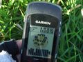
Mandatory GPS photo
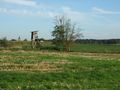
View from the hash

