2010-10-09 49 9
| Sat 9 Oct 2010 in Würzburg: 49.6427434, 9.8359639 geohashing.info google osm bing/os kml crox |
Location
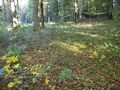
Today's location is in a forest near Kirchheim.
Country: Germany; state: Baden-Württemberg (EU:DE:BW); administrative region: Stuttgart; district: Main-Tauber-Kreis
Weather: sunny
Expedition
Danatar
Hashpoint in reachable distance - check; Saturday - check; No work - check; No other plans for the afternoon - check;Good weather - check; Bike in working condition - check
I cycled through Würzburg and along the country roads I had taken on my very first German expedition. Cycling went fine. On my way, I stopped a few times to save caterpillars from probable death on the road, and once to mourn a roadkilled cat. A few minutes before 4 pm I reached the edge of the hashforest, which is the border between the German states Bayern and Baden-Württemberg. I was able to cycle on the forest tracks with a bit of effort and I stopped near the hashpoint at 15:58. The last ~20 metres were easy and I reached the hashpoint one minute before meetup time, just in time for a picture. Nobody else was there and I spent some time taking pictures of the surroundings.
When I started to walk back to my bike at quarter past 4 a motorcycle drove past on the forest track and the pillion rider waved to me, but apparently they weren't geohashers. The way back home was more difficult and I had to stop a few times to rest my untrained legs.
I cycled 47.8 km.
almost there
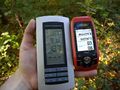
GPS at 4 pm

Coordinates reached!

Nibs. NIBS. NNNNIIIIIIBBBBSSSSSS! OM NOM NOM NOM! MUHAHAHAAA!

panorama
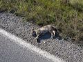
roadkilled
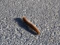
not roadkilled


