2010-11-13 59 18
| Sat 13 Nov 2010 in 59,18: 59.7976517, 18.0669944 geohashing.info google osm bing/os kml crox |
Contents
[hide]Location
On a small road in the forest outside Knivsta and Uppsala.
Participants
Plans
First head down to the city to buy a GPS device. I hope the one I've looked on (online) is what it seems like and is ready to use right away. It's using standard batteries so that shouldn't be a problem. After fixing with the GPS device I plan to head down to the train station and take a bus from there. After a 30 minutes ride I'll have to continue 7km by foot to the hash. The bus back goes 30 minutes after arrival, 2h 30 min, 4h 30 min and so on. I won't be able to catch the 30 minutes one but hopefully the 2.30. At the very least it won't be later than 4 and a half hour after arrival. Thirty minute back and then I'll head home. I haven't decided about when to go yet.
Expedition
To the bus!
After grabbing the camera and two AA-batteries I headed off by foot. After x km I reached the store in the central part of Uppsala that I was after. There I bought a Garmin eTrex Legend HCx GPS device and a memory card for it. I hope this will be my most expensive Geohash of all time. After buying it I went to the train station where I was going to take bus #677. While waiting for the bus to come I put the memory card and the two batteries I'd brought from home in the back of the GPS. This is when the tracklog starts(see below). Then the bus arrives and I tried to pay with cash, but apparently they didn't accept cash on this type of bus so I had to pay with my mobile phone. Luckily I had enough money on my phone for both ways(I checked before paying the first time).
Confusion on the bus
On the bus I tried to add the coordinates into the GPS. First without success. It didn't accept my coordinate. The reason was that the coordinate I wrote didn't exist. That was very strange cause I had checked it at home and written it on a piece of paper I had with me. After a while I realized the coordinate format on the GPS wasn't the same as on my piece of paper. Of course I could've changed the GPS's coordinate format to the same I had on the paper but it took some time before I realized. Now when I had had problems with both the bus payments and the coordinates everything seemed kinda bad and then the recorded voice on the bus announced my bus stop, or at least that was what I thought. I went of the bus and it drove away. Now I began to wonder if this really was my bus stop or not. But since I didn't had any other options I headed on the road north as planned.
Off track
Since the bus stop wasn't the correct one, the road wasn't either. It turned very fast into a dust road. Not a bad one but it was still a dust road. I thought that I maybe had seen wrong at google maps and the road actually were this small. I didn't thought straight because of the incidents on the bus earlier. I didn't noticed that the road actually headed east, not to the north. The after some time walking I all of a sudden found a big road that my road ended up on. I'm was very confused, where did this road come from? I followed the directions of the GPS and turned left onto that road. After a while I realized what had happen.
A stupid decision
My bus stop should have been in a traffic circle. I didn't left the bus at a traffic circle. I walked North now after a 90 degree turn, the last road couldn't have gone north. I realized that I now were on the correct road and that I had been kinda lucky finding it so easy after all. I followed the new road north for a while and then, because I didn't had any experience with a GPS, I thought it was time to head into the forest, which I did. This was a very stupid decision(just check the tracklog below).
Swimming in the forest
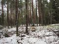
Walking in the forest was very slow. Normally it goes kinda slow but now it went even slower. A couple of days ago it snowed for the first time this winter(enough for it to stay). And since it's just the beginning of the winter it's still kinda warm. So the snow was currently melting kinda fast. It was water everywhere(not really but it was a lot) in the forest. It was difficult to find a good way around the big water masses. I didn't had any boots and it wasn't deep enough to swim in and I didn't had any boat. I couldn't walk on water either. What a pity. So I walked in the forest in about 2 km/h and it wasn't in a straight line.
Birds and Apples
When I was walking slowly in the forest I heard a very load flapping sound. I didn't saw anything at first but then I saw a huge bird flying away. I'm probably exaggerating a bit but its wing span was probably like 2.5 meters. After this I continued and then later on find some tracks from a human boot. I followed it for a while since it went in the same direction as the GPS showed. The boot tracks went to a fresh heap of sliced apples. Now I got a bit scared, what if I were in the middle of a hunting area?
Roads
I was kinda tired at this point after the hard walk in the forest and together with me being a bit scared and the 2 km it was left to the hashpoint it was enough for me to give up. I made a turn and headed NWW instead of NE. After a while I found a little forest road and followed it back to the main road. When I saw it I thought this was the road I had originally looked for, I thought of how much easier it would've been if I wouldn't have turned into the forest. Afterwards I found out that this road wasn't even close to the road I was supposed to take(see the track log once again). On the main road I went south, I saw on the clock that I could catch the next bus if I went straight on. Else I would have had to wait another 2 hours for the next one.
Home and Happy
On the way back I didn't used the dust road but continued south where mu actual bus stop was. There I found the traffic circle and the bus stop. I were 30 minutes early though so I weren't even near missing the bus. After waiting for the bus I took it home without any more problems. From the train station I then started the way home. At this point my heels wasn't feeling too well, my socks wasn't good enough. But apart from that the last part of the trip went fine. After five and a half hour I were home again. It was a fun and interesting trip even though I didn't found the hash point. I learned by my mistake and I think that it was kinda good that I failed at my first GPS trip. Now I won't do the same mistake again. I will claim both the MNB_Geohash and the Prize_poultry consultation prizes for this trip since my failure was because of all the melting snow(that tired my legs so) and because of me being scared of maybe being inside of a hunting area. (I removed MNB because I don't think it was extreme enough anymore)
Tracklog
Tracklog[1]. The tracklog starts at the bus stop at the train station and ends a little while before I reached my home.
Photos
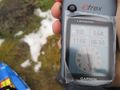
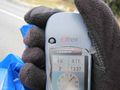
5.64 km, that shouldn't be so hard...
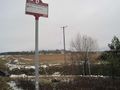
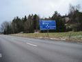
The wrong bus stop.
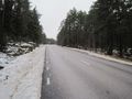
The road turned into a dust road, pretty good quality on it though.
What's that road doing there?
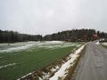
This road was much larger, but where are everyone?
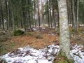
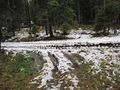
Into the wood. Bad decision!!
A chair...
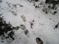
Two boots have walked past, probably worn by a human.
A forest road
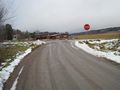
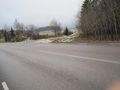
Back at the big road.
Where's the moon? It should be here about... IN THE MIDDLE OF THE DAY!?!?
The dust road again. This time I won't take it.
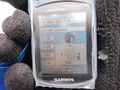
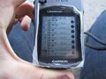
L33t
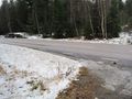
The traffic circle where I should've gotten of the bus.
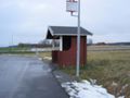
The correct bus stop (bad picture though).
Proof that I failed on the right day.


Achievements
Vswe earned the Prize poultry Consolation Prize
|