2010-11-22 43 -79
| Mon 22 Nov 2010 in 43,-79: 43.8285787, -79.2565154 geohashing.info google osm bing/os kml crox |
Location
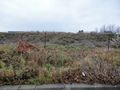
The geohash point was located in an undeveloped lot in an industrial area of Scarborough. The neighbourhood name is... Armdale? Really? Okay, so it's in Armdale.
Participants
Plans
I've been to this area on a previous outing, specifically 2010-10-30 43 -79. This time, I'm going to pop in after work by car. It looks to be an undeveloped lot, which means there's probably a fence around it I can't see on the satellite image, but I guess there's only one way to find out.
Expedition
After finding a parking spot behind a building to the east, I immediately notice that there is some fencing, but not a complete fence. In some parts, there's only posts, and in other parts there is snow fences, but no actual fences. I walk around to the front of the lot only to find a much better looking fence. Halfway down the lot, I was lucky to find no fence at the entrance.
There were some large stones at the entrance, but I think those are to keep vehicles out, not people. Also, no 'No Trespassing' signs. I go for it.
Being a bit moist during the day, the ground had a very muddy clay feel to it. I tried to stay on top of plants as much as I could. However, when I came to within a dozen meters, I realized I was standing on the banks of a very large puddle. Nay, the Extremely Large Puddle. I'm not sure if the acronym should be ELP or XLP. The good news is that it looks like the direction and distance places the point near an adjacent shore. I detour around some more mud and water (and through some other mud) to get to the point.
After capturing the required photo evidence, I decide on making a bee-line back to my car, 'Em.' Going through some more mud, over a small embankment, over a tiny ditch, I get back to 'Em,' use some serviettes to clean my shoes, and head back, triumphant.
Photos
Do you call that a fence?
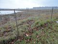
Now that's a fence. Er...
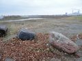
Never mind the fence, this entrance is inviting.
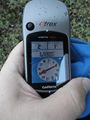
Sucess.

Posing infront of the Extremely Large Puddle.


Achievements
- Land Geohash
Nothing new I believe.