2010-12-10 50 9
| Fri 10 Dec 2010 in 50,9: 50.8660290, 9.7969332 geohashing.info google osm bing/os kml crox |
Location
Up a hill in the forest not far from the Autobahn A4.
Participants
Plans
On our weekly way home we planned to make a little detour to get the first hash in that graticule and to get closer to a full minesweeper achievement.
Expedition
Two words: miserable fail. We started out early enough and didn't even hit any major traffic jams. So far so good. We decided to stop for a quick coffee and a toilet break on the way when we suddenly noticed that we actually has just passed the exit which lead to the hash ... *argh* subconcious hashing is obviously not working as good as we thought.
We turned around anyway as it was only a mere 5 km back to the correct exit and followed the road around a little stream to get to the bottom of the aforementioned hill. It was cold but not freezing and although there was a lot of snow still lying around, it was at least dry from above.
Rincewind decided that we shouldn't have to walk 1.5 km to the hash and started driving up the hill on backroads through 20-30 cms of snow - yes, he's a little mad and has a lot of faith in his car but hey, madness does help when geohashing, right?
It didn't quite get us all the way there and we eventually decided to walk the rest of the way. The walk was nice and peaceful, nothing but trees, lots of snow and the occasional animal track crossing our path. At least that's what it felt like for the first kilometer, before it started to get dark, the feet became cold and wet and the hash didn't really come any closer (bad hash!).
There were two possibilities according to Google Maps: the hash could either be right on the path we were following (if the map was right) or between the said path and the next one going in parallel up the hill (if the satellite image is right). Unfortunately for us the latter turned out to be true.
We eventually found a ... well ... "way" connecting the two (it was ridiculously steep and we only knew it was there because we followed the tracks of a skier that must have passed by earlier - going down rather than up) but we ended up circling around the hash and it was too dark and too steep to attempt to get to it in the middle of the woods off the tracks.
Closest we got was 26 meters which still is a "not reached".
By then it was too dark to go back down the steep slope so we took a different way back hoping it would lead us back to the car - which it did eventually but not without twisting and turning for a loooong and cold and "wet feet" time.
All in all a great fun but - seriously - what a useless hobby this sometimes is ;)
(OK, we can at least use the tracklog to add a couple of streets to OpenStreetMap ... if I can find out how ...)
Tracklog
See here.
Photos
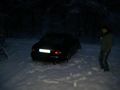
Hash-cat ...
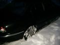
... in the snow.
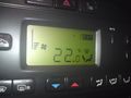
Freezing hash candidate ... only we didn't reach it (outside temperature is the '-1' at the top not the '22' - doh!)
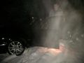
Uuuuuuhhh, scary Hasher.

Missing! Reward!


Quotes
"I don't need children, that's for sure. Raising THAT one is quite enough." (Rincewinds Girlfriend upon hearing the story of him being rather late because of the hash attempt.)
Achievements
Mampfred and Rincewind earned the Cliffs of Despair consolation prize
|