2010-12-18 35 -106
| Sat 18 Dec 2010 in 35,-106: 35.4830007, -106.8931253 geohashing.info google osm bing/os kml crox |
Location
Just off the dirt road just outside of the Ojito Wilderness
Participants
Plans
Got a lot going on today, and I'm not sure of the road condition due to the recent snow. SO, I'm gonna head out that way extra early in order to (hopefully) catch the road in passable condition and still get back in time to do everything I've got on the schedule. I'd love to say I'm gonna catch the sunrise hash, but I think I'll beat the sun on this one.
Expedition
Dragged myself out of bed and got on the road silly early. The trip out US 550 was as quick and easy as expected. It wasn't quite a cold as I'd hoped for (right around freezing), and I found the dirt road pretty muddy/slushy. This would likely not have been passable later in the day. At any rate, I made it out to the spot without TOO much effort. I pulled off the road and walked the tenth of a mile or so over to the hashpoint. The area was shrouded in a chilly snow-caused fog, so I wasn't particularly tempted to hang out for very long (although with better weather I would have been crazy tempted to go hiking in the nearby wilderness area). Anyway, I got back on the road and headed for home. Mission accomplished.
Track
The track is located here.
Pictures
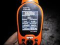
GPS coordinates in the dark.

Grin (in the dark).

