2010-12-18 42 -70
Jiml and Phyzome reach a geohash on a golf course in Swampscott.
| Sat 18 Dec 2010 in 42,-70: 42.4830007, -70.8931253 geohashing.info google osm bing/os kml crox |
Location
Golf course in the Lynn graticule. Some lovely beaches nearby.
Plans
- Phyzome: I have no constraints, and Jiml is in town...
- Jim's enthused about visiting another graticule, but is not enthused about swimming when it is well below freezing...
- Phyzome just wanted to see the rocky beaches, not go swimming!
Participants
We have made plans! Planning to be at the hashpoint around 2:00 PM, give or take a half hour. Driving from Somerville area.
Expedition
And we are on our way! Jiml 19:10, 18 December 2010 (UTC) and Phyzome, at Blue Shirt Café.
We headed out on Route 128 / Interstate 95, looping around to the north to avoid traffic. The trip was fairly uneventful, though Phyzome was kept busy in the passenger seat juggling a GPS receiver, a BlackBerry with intermittent data access, and a digital camera with snapshots of the route.
Circling the golf course, we noted a complete lack of golfers. There was plastic covering what might have been water traps, and the green was deserted. From Crossman Ave, where we parked, we could see a family playing with their dogs in the distance. There were steps leading up to a break in the fence. Clearly, no need to ask for permission to go onto the green -- this looked more like a neighborhood park than an exclusive course.
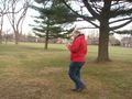
Jiml did the zigzag GPS countdown march, finding the spot in front of a large conifer. Victory! Phyzome's first hashpoint in the Lynn graticule. We posed for silly grin photos and hash proof, watched the dogs chase each other in the distance, and finally headed back to the car.
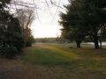
We took the coastal route back to Somerville, keeping close to the shoreline. Beautiful sunset over the water, and we could see the Boston skyline in the distance! Phyzome recognized the route back home, having traveled it once before, and while he avoided directing Jiml out onto the Nahant causeway, he did make the same navigation error as last time at the 16/1A split after the Revere traffic circle. All in all, a fairly smooth ride home.
Photos
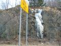
It was cold out!
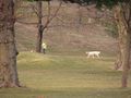
Dogs on the green...
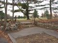
...and steps. I think we're clear.
More like a park, really.
Counting down the feet.
- Error creating thumbnail: Unable to save thumbnail to destination
Victory!
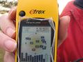
Closeup of the coordinates.
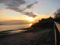
A view of Boston over the water.


Achievements
Phyzome and Jim earned the Land geohash achievement
|
Error creating thumbnail: Unable to save thumbnail to destination |
Missed opportunities:
- Golf Geohash achievement -- could have even grabbed a golf ball off the course.
- Tron achievement: We almost certainly walked over our own path on the golf course, but if we hadn't had to retrace our path in the car after that one traffic circle, it would have been possible.