2010-12-28 64 20
| Tue 28 Dec 2010 in 64,20: 64.7525290, 20.5019278 geohashing.info google osm bing/os kml crox |
Location
In a forest, pretty near Krånfors, Skellefteå. About 20 km from where I currently live(vaccation at my grandma's).
Participants
Plans
Head out in the morning (when it's still dark). Hopefully return before it gets dark again(it's just light a few hours here).
Expedition
Let's Go
I left some time before 8 AM, it was about -22 degrees C outside and I had about 40 km of walking ahead of me. I took a kicksled and started my journey. After some time I stopped to take a picture but the camera told me to change the battery, the battery was almost newly charged and I had only took a single picture earlier on my travel. The electronics really didn't liked the low temperature. However I knew that the phone I had with me had a camera in it and therefore I continued on my kicksled without thinking too much about the "broken" camera (on a sidenote, the camera worked perfectly (in the warm house) when I came home).
It's not only the camera that is cold
After about 6 km I arrived at a somewhat bigger road and I left the kicksled there. I left it because of a few different reasons, including: me being cold and the road wasn't too good kicksledding on today. Continuing on foot I walked for a while and I can assure you, it felt a lot colder than -22 and I think it was, some said that it was about -27 over there. However I felt that my face had frozen so I searched for the phone and took a photo of myself. I almost froze my hand off. The ice in my face doesn't prove the low temprature but you can surely tell it's below 0. Therefore I think it's time for me to claim the Frozen Geohash achievement (all my previous expeditions have all been below zero though).
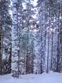
Into the forest
After a total distance of about 19 km or so I reached the very small road I were looking for. It was some snow on it but not as much as it could've been. Only about 30 cm instead of the 100 cm depth it could've been. I followed the road in the snow, it was about 700 meters left to the hashpoint now. After some walking my mood dropped when a cliff suddenly appeared at the right hand side of the road. It was at least 25 meters down and if the hashpoint was down there I wouldn't be able to reach it. And I knew that the hashpoint was about 50 meters off the road, at the right hand side...
Hashpoint time?
After following the road a bit more it turned left a bit and moved away from the cliff. I didn't knew if this was enough though, a distance of 50 meters was needed. At this time I had been out in the cold for a couple of hours and all my sweat from the walk had frozen in my face. In my eyebrows and eyelashes I had ice balls as big as ping-bong balls. I had to remove them since my view was decreased and I had to see properly now when I were close to the hash. I left the road, 50 meters to go. After 25 meters I looked back, I wasn't sure If I had walked half of the way to the cliff, I was afraid I hadn't. 10 meters to go, the cliff was very close now, 9 meters... 8 meters... 9 meters. Happy face. I turned about 120 degrees to the left and found the hashpoint, just a few meters from the cliff. I took some picture and almost froze my hand off once again.
The way back
I ran back at the small road to get warm again. After some time walking I felt pretty tired in my legs and I didn't want to have a replay of my last long walk where I couldn't walk properly for a few days afterwards. I called my mum and she picked me up. At this time I had traveled a distance of about 30 km. I could check better when I can see the tracklog.
Tracklog
Due to some technical issues the tracklog doesn't contain any timestamps. Tracklog[1]
Photos
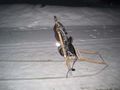
The kicksled I used.
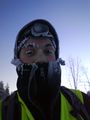
All white stuff on me is frozen sweat.
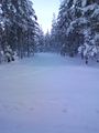
That's where I'm going. 700 meters to go.
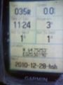
Proof.
The cliff (taken from the hashpoint). Notice the trees.
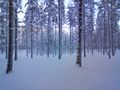
View from the hashpoint.


Achievements
Vswe earned the Frozen Geohash Achievement
|
Vswe earned the Land geohash achievement
|