2011-01-11 48 9
| Tue 11 Jan 2011 in Stuttgart: 48.9327571, 9.3329787 geohashing.info google osm bing/os kml crox |
Location
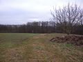
Today's location is in a field with young plants between Affalterbach and Kirchberg an der Murr, not far from Ludwigsburg.
Country: Germany; state: Baden-Württemberg (EU:DE:BW); administrative region: Stuttgart; district: Rems-Murr-Kreis
Expedition
Danatar
I had to go to Konstanz and the hashpoint was near enough to the Autobahn to make a detour. I left the Autobahn and followed my notes to Marbach am Neckar. My plan was to go to Kirchberg an der Murr next and to approach the hashpoint from the north, but I found myself in Erdmannhausen instead with signs leading to Affalterbach, so I took the route that imposed itself upon me. I left the car at the beginning of a field track and walked along orchards towards the hashpoint. When I came nearer, I found out that the spot was a few metres inside the hashfield and that small plants were growing there. So I just took a picture of the GPS on my outstretched arm, about 3 metres from the hashpoint. Under a nearby apple tree I found some old apples and I put one on a stick at the edge of a field as a marker. Then I quickly went back to the car and continued my journey. The whole detour had taken almost exactly one hour.
almost there...
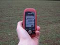
GPS

stupid grin

panorama
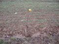
apple-onna-stick
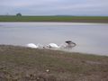
swans and a goose in a flooded field near Affalterbach


Danatar earned the Last Man standing achievement
|