2011-02-09 51 11
| Wed 9 Feb 2011 in 51,11: 51.2400393, 11.1491208 geohashing.info google osm bing/os kml crox |
Location
On a field near Büchel, Sömmerda district, Thuringia.
Participants
Plans
Reach the hashpoint. In daylight. Document the expedition, even.
Expedition
Since I had the early shift at work, my chances of reaching the hashpoint in daylight were better than usual, also helped by the fact that days are already getting significantly longer. I drove from work using my car navigation and, when I'd arrived in Büchel, changed to the "outdoor unit". It was a mere 300m to walk from the road, yet I had to cross a railroad track. After carefully checking for trains (a few regional trains only, slight chance of getting hit by a 300km/h ICE train...) I stood in a field and came to a rather annoying conclusion: Between autumn and summer, there is only three kinds of countryside hashes in Thuringia: Frozen hashes, hashes in the woods and ankle-deep-in-mud hashes. Said mud is a really good soil and is heavy, stickier than concrete and just as hard to get off the shoes, whether dried or wet. I think I just won't clean my outdoor shoes anymore, at least not before mid spring...
Back to the hash: Quickly skipped through the mud (had a bit of wading over Lake Greenfield or something) and rather easily got to the hash, once the soil got drier.
Got back to the car on a slightly better track, changed shoes again (really glad now for two pairs of shoes!) and then headed back home uneventfully.
Hmpf, and I tried to be a bit shorter with the report this time, but my tendency towards dramatisation beat me, again. ;)
Photos

Trabant enroute- THE symbol of East Germany's mobility and now, a cultic vintage car.

Driving from the setting sun...

As good a sunset as my mobile will photograph it...

Work off, hashing on.

Single railtrack attempting to stop me from hashing

Walking through fields of hash...
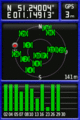
Of course, the coordinates jumped when taking the shot, but still...
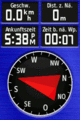
...coordinates reached! :)

Actually a stupid non-grin on the way home, and it's dark now.


Achievements
Rincewind earned the Land geohash achievement
|