2011-02-09 52 21
| Wed 9 Feb 2011 in 52,21: 52.2400393, 21.1491208 geohashing.info google osm bing/os kml crox |
Location
Playground near 135A Korkowa Street in Marysin, Warszawa, Poland.
Participants
- Adoomer
- Tolkjen
Plans
- Introduce a friend to geohashing
- Reach the hashpoint just before sunset
- Claim the Warszawa East Virgin Graticule
Expedition
I've been waiting for a convenient hashpoint for about a month, and when this opportunity appeared (only 10 km from home), I called my friend (Tolkjen) and briefly described him the idea, because he never heard of geohashing. The weather was very good for this time of year - nearly clear sky, a bit windy but no snow, 3°C.
I checked the spot on Google Maps thoroughly, recognizing that it could be easily reached by bus. Therefore we took #173 to Marysin and talked about Lovecraft's horror short stories on the way. As we got off the bus and joking further about cursed crypts and blasphemous books, we had a chance to admire the view of a setting sun. After a short walk with a smartphone in hand we got closer to the hashpoint and took out more precise (as I thought) GPS receiver.
Finding the right spot was not an easy thing because of a bit poor quality of the navigation device, and my extremely poor skill of using it properly (next time I'll exercise more before going out...). Eventually, we got to the playground and stood there for a while, not being completely sure about the hashpoint, but trying to confirm the result.
Then the receiver got completely mad and directed us about 30 meters north. Because of our long struggles with hardware, it already got dark and gloomy. Having nothing better to do, we followed the directions and walked away from the buildings, up the old concrete stairs and along the dark pathway leading into the dark, leafless forest... Yeah, "blasphemous" atmosphere ;-).
Finally we got as close to the designated point as possible. After moving one meter in one direction or another, the receiver was changing coordinates for 2-3 seconds of angle, so we were trying to catch the right value by walking no more than one or two meters, and eventually ended with two photos displaying (separately) the right longitude and latitude.
We left the dark forest and observed by the moon we headed to our final destiny... erm, destination, guessing, that the world will never be the same as before...
Photos

Adoomer (left) and Tolkjen (right, with the gloomy Lovecraftian face...) on the bus.

Setting sun; on our way to hashpoint.
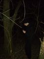
Tolkjen chasing the hashpoint.
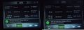
The proof... the proof is out there...
Tolkjen on spot

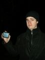
Adoomer on spot

Stupid Grin tm


Achievements
Adoomer, Tolkjen earned the Land geohash achievement
|
Adoomer, Tolkjen earned the Graticule Unlocked Achievement
|
Adoomer, Tolkjen earned the Public transport geohash achievement
|
Adoomer earned the Drag-along achievement
|