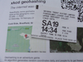
2011-02-19 53 -1

| Sat 19 Feb 2011 in 53,-1: 53.4659988, -1.7658674 geohashing.info google osm bing/os kml crox |
Location
Officially: "Cold Side, Bradfield, Sheffield S3 0, UK". Practically: on the hillside above the upper reaches of the River Derwent, above Howden reservoir.
Participants
Monty started out, at least.
Plans
Monty will hopefully head out towards Ladybower Reservoir by car and is planning to get there about 11am. Depending on where the public parking and limit to public vehicle access is these days, the walk is then onwards past one or more of Ladybower, Upper Derwent and Howden reservoirs.
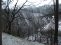
The journey will be past or over Ridge Clough, Linch Clough, Lower Misden Clough... face it, a lot of Cloughs. Opposite something marked as Deer Holes on the opposite (south) side of the valley and below the top called Horse Stone, above the rocky sloping ridged names as Horse Stone Naze (to the north) there may or may not be opportunity to strike out up the slope.
Aerial photos indicate peat cutting patches, the map indicates 'marshy' ground. So it's not expected to be a proverbial walk in the park, but it should only be 250m of trek, or so, from the nearest point of the path. Horizontally, that is. If the nearest bit of path is at approx 390m, the location is perhaps at 425m.
As per prior expeditions, without GPS the navigation will involve general awareness of the landscape and a compass.
Upon gaining whatever possible degree of success might happen, it would be nice to head over the Howden Edge and eventually down to Langsett on the northern side of this moorland area, but with the car at the southern edge, that probably won't happen.
The biggest problem to be foreseen is that the weather forecast is minded to mention sleet, snow and heavy rain, for the morning. And that's just looking at my home town. On top of that, I'm needed somewhere else by late-afternoon, so there's no guarantee I'll complete this challenge before having to head back if things turn nasty. Still, they can't all be winners, and I shall endeavour take all precautions and care.
Expedition
7:30am: Awoke far too early to see it sleeting down outside. By 7:50, it's settling. Still, as it seems I can't find my map-case, will have to wait for shops to open to buy this necessity anyway, so still 2.5 hours before even considering leaving the house.
10:30am: Off out, for better or worse. Have some places to visit in-between, so arrival at head of Ladybower (probable limit of road, at weekends, IIRC) closer to noon, by which time the weather sounds like it might be clearing, only leaving the white stuff under-foot. Very much anticipated that one or other of the Mother Nature Achievements shall be relevant, but only truly deserved if I actually get to the path beyond the top reservoir.
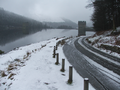
12:30: The roads were relatively clear. It looked like plenty of people had already decided to travel along them. But it still made for an interesting journey out. Turning up into the Upper Derwent Valley road, foremost in my mind was that it was much later than my intended ETA, and that I knew that on weekends and bank holidays one could only get to the bottom of the first dam (the Derwent Reservoir). A quick look at the map showed that up to the top of the top-most reservoir was about 3.5 miles as the snowgoose flies. The road wound around the western edge a bit, the alternative was to take the path on the eastern edge of the valley which was straighter but wouldn't be as easy going. I knew that I could easily walk at about 6mph without much effort on tarmac, around 4mph on a good path. I thought it would be a good path, on the eastern side, but I knew it'd be a good road on the west. Beyond the top end, I estimated about 2 miles of walking on path to the locale of the geohash, regardless of whether I went cross-country to find it, but I had to be back down within three hours.
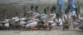
The car-park was Pay-And-Display. £2.50 for two hours, £4.00 for all day. A quick cost analysis made me plump for the former. It would take some doing, but I had by now decided that I probably wasn't going to be spending too much time to get beyond the head of the upper reservoir, anyway. Going up the road would be fastest. So after avoiding the ducks (on the way in, the sign had warned to be slow, for the sake of both children and ducks, and a fellow visitor had offered up some food and ended up with a large number of ducks zeroing in on him), I found a path back up to where the road was.
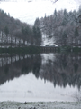
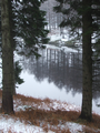
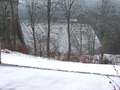
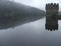
12:45: Passed the first Dam (not counting Ladybower's, of course). Derwent Dam was one of the practice ranges for 617 Squadron, the "Dambusters", they of the bouncing bomb. But of all these ranges, it was also immortalised in film of the whole wartime episode. Beautiful reflections across the water, and a a few quick photos taken of the more striking views.
13:05: At Ouzelden Clough bus stop. "Weekend Minibus Service", advertised. At this point, I realised that I had made an error. During summer, Saturdays, Sundays and bank holidays were no-traffic times, but there was a Winter Schedule. Only Sundays were no-traffic (apart from locals/official vehicles). Today, I could have driven up. What's more, it being a non-closed day there was no bus due, so I couldn't even take advantage of the public transport. Oh well, onwards and upwards.
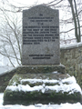
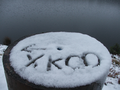
13:25: Passed Howden Dam. Just needed to get to the other end. Unfortunately, the road (because of the reservoir doing the same) diverted quite a lot into the western valley side. And with just ten more minutes before 'half-time', I now knew I wouldn't even make this last trip. (Only afterwards, actually making some half-way decent measurements on the map did I find that the top of the uppermost reservoir was around 7 miles by road. The eastern-side path, by contrast, was approx. 4.5 miles distance.) Shortly afterwards, having already passed at least one other strange flat-topped pillar, I decided to do my bit for the cause and scratch an "XKCD" sign in the snow in the top.
13:35: Well into the western spur of Howden reservoir, and with little chance of getting any view of the top end, finally turned round and officially abandoned the attempt. It never got to the point where I was Mother Nature's Bitch, 'cos Father Time got there first.
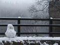
14:15: Yes, the return trip happened faster. Downhill, yes, but also probably because there were less photos being taken. Just above Howden Dam, I discovered that somebody (possibly a couple I'd seen passed walking upwards, not much earlier) had made something vaguely describable as a snowman. Now why hadn't I thought of doing that?
14:20: Avoiding the ducks, once more, arrived back at the car. Shortly after, drove back out onto the main road. (Seemed silly to drive to the top, and rather irreverent towards the walking I'd done to get me 80% or so of the way there.)
In hindsight, many errors. First and foremost, not driving to the top. Secondly, having not done that, not taking the all-day parking option to allow that little extra distance, at least. Thirdly, not going back to the car having wasted only about 40 minutes walking. Fourthly, not having gone up the eastern edge, at the risk of then taking the road back and ending up with a parking violation.
Still, I have a plan. The next Saturday when I have time and am not heading towards another geohash (or can integrate that geohash because it's in the same general area or direction of travel), I shall Retrohash this spot. This geohash spot appeals to me on so many levels, and I'd like the opportunity to exorcise this particular failure.
And it was a good day out.
Tracklog
None from me.
Photos
My preparations
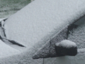
A dusting of snow
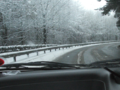
Not so bad road conditions
Afterwards, I'd go via The Strines
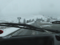
Nearly time to start walking
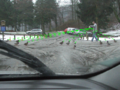
Duck season. Bread season!
Should have shot the even wider-angle
One of my mistakes
Bigger than it looks
Good dog
Across the Derwent
Another reflective shot
They're not quite flocking to this place
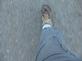
What's afoot? Athingontheendofyourleg!
No mere weir
No, I wasn't tempted to take a dip
Looking back where I'd come from
I didn't actually get that much further
Someone made the effort


Achievements
Monty earned the "Father Time's Bitch" Consolation Prize
|
While technically yet another No Batteries expedition, did not get close enough to justify earning this or any other Achievement.
Retro
Building on my "Lucky Thursday" streak, the retrohashing of this spot was attempted and (within No Batteries limits) achieved during the Thursday, 24th February 2001 trip. This is place-holder text prior to having time to compile the details, new photos, etc.