2011-02-24 53 -1
| Thu 24 Feb 2011 in 53,-1: 53.3315820, -1.8303965 geohashing.info google osm bing/os kml crox |
Location
In a thin triangular copse, west of Winnat's Pass.
Participants
Plans
This was very much a spur of the moment expedition. To which a retrohash was added. There turned out to be nothing I needed to do in the morning and as I'd already speculatively checked on the day's geohash, worked out it should be accessible and worked out the academic details but had considered it a bit too far over the hills to get to with my usual schedule, suddenly it was obvious to me that the day was "on"!
Expedition
It could not have escaped me, as I turned off down to Bamford at Ladybower Reservoir, that I was also quite close to Saturday's failed geohash. Up until that point the journey had been over most of the same roads since even before leaving Sheffield itself. The difference being that Saturday's snow had gone, and today was a bright day with a promise of sunshine, and the only moisture on the windscreen came from a bit of inefficient "wipering" that was really no substitute for properly cleaning the car inside and out regularly.
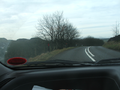
Along the Hope Valley it's fairly flat, one reason why there's a railway line along there. It occurred to me that yet again I was using a car where public transport could have been at least partly utilised. Only it wouldn't have been quite so convenient. I'm not sure as to cost, but I suspect it wouldn't be cheap, either. At least not with less than a day's notice, and the need to find alternate transport away from the iron rails. Plus, the car had been used first thing in the day and would be needed last thing. C'est la vie.
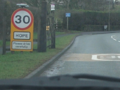
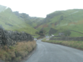
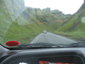
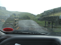
Passing through Castleton, the next junction was the left turn up to Winnat's Pass. Interestingly, if you're not already familiar with the area, the main road apepars to continues straight forward, but this now leads only to a dead end. Winnat's Pass is a steep and rock-lined road up out of the Hope Valley onto the heights of Rushup Edge that eventually fall down onto the western foothills of the Pennines. An ancient route, it was considered unsuitable for a heavy amount of traffic, or indeed heavy vehicles. So the main road for most trans-Pennine travel through this particular pinc-point was sent up the side of Mam Tor. This loop around the less cliff-like hillside is about double the mile or so distance of the Winnat's Pass road, but gentler in gradient.
A perfect plan. Except that Mam Tor has a little problem with land-slippage. Cracks reguarly appeared in the road, were mended, whole sections redone on occasion when the slip went too far. But it kept happening, and now the road is permanently closed. Not that there were any from this expedition, but I've got some good photos somewhere of the road that looks like (with all due apologies for the topicality of the incident in Christchurch, NZ) an earthquake has happened. Well, I suppose technically it did, but slower and more local. Anyway, now all traffic (except heavy goods vehicles, who are barred) is back in Winnat's.
Which sort of did for, if you'll pardon a bit more reminiscence, a very successful cycle-race location. There was a rather famous cycle Hill Climb up Winnat's. Spectators from far and wide used to flock (usually by bike) to line the roads and slopes around Winnat's to watch this challenging course. In the earliest days, traffic was not a problem. Later on, when it might have been, the road was closed to traffic and everyone went via Mam Tor. Notice the current flaw with that plan? Anyway. I can't really do the pass the justice of description it deserves.
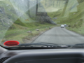
Having reached the top, it's not far now. As for prior hashes needing tree-based navigation, the time of year has made the various on-line overhead and road-view photos a little inaccurate w.r.t. 'leafiness', but the small copse remains recognisable. A long, thin triangular patch of trees, constrained by by an acutely angled side-road that's little more than a farm-track, and marked as a bridleway. And in there is my destination. And a good place to park up is that track end.
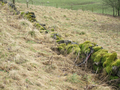
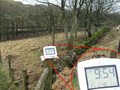
Finding the exact spot (sorry, it's a recurring theme with me, at the moment, but it's a No Batteries hash again) is a matter of checking the overhead map that I printed out. The marker appears to be on top of a particular tree, and the copse is not so dense on the main road side (bits of the area have hardly any trees). Walking along there, there is a small dry stone wall, but in significant disrepair and not so much stepped over as avoiding accidentally tripping over an errant bit of rock. Which I'll cross in a moment, once I get my proper bearings. I know that the north-eastern corner is (from the map) 20 degrees east from assumed North, so I take a bearing of 200 from that corner. (I had measured the other corners, as well.) I happen to know that Magnetic North is about 2 degrees west of my map's grid-north, a little less from True North, and don't fully know how the overheads are lined-up, but it ends up being a trivial task, as I'm pointed towards a particular tree which is so obviously has the correct relationship with several other isolated trees.
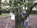
A quick walk over to the tree, checking the other bearings as best I could but really only as a matter of formality, and I considered the expedition a success. For once, I remembered to get a shot of me while taking the photos (tripod and the camera timer assisting in that task), although I consider myself far from photogenic.
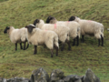
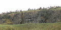
Walking back to the car, I found that the field full of sheep on the opposite side of the road were sporadically watching me. Ok, so despite my own self-impressions, I suppose I was something novel to look at, being neither sheep, wall or fast-moving car. But when I found a large contingent of arian black-faces staring down at me from the top of a quarry, it made me think of The Italian Job (original version!), and the bit where the sports cars are road-blocked and then disposed of by the mafia. For most of the rest of the day I was humming or whistling the intro music to the film, albeit happily in the knowledge that I wouldn't be driving through any tunnels at any point.
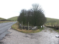
Steps were retraced back down Winnat's, Castleton, along the Hope Valley, up through Bamford and past the Ladybower Dam. Having crossed the bridge across the reservoir and approaching the A57, a second film reference comes straight to mind. In Indiana Jones And The Last Crusade, there's the choice between Berlin (for the grail book) and elsewhere (to find Marcus Brodie). The camera wavers between the two arms of a sign, before heading off to Berlin and taking the two Henry Joneses with it. My internal camera waved back and forth, between going to the right, homeward bound, and heading left to re-attempt the previous Saturday's totally ill-timed geohash attempt. As the moment approached, I finally decided to go for the retrohash.
Tracklog
None.
Photos
Well on the way...
An interesting road
Not as level as it looks
Somewhere in there
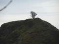
I now know that this is a tree
Now on foot
Easy access
A bit of time proof
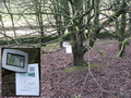
An alarmed tree
Tree's company
A black look from a black-faced sheep
Mafia sheep
A pass-ive return
Still doesn't look as steep as it is
Decision time


Achievements
Monty earned the Land geohash achievement
|
Monty earned the No Batteries Geohash Achievement
|