2011-02-17 53 -1
| Have you seen our geohashing marker? We'd love to hear from you! Click here to say "hi" and tell us what you've seen!
Curious about what geohashing is? Read more! |

| Thu 17 Feb 2011 in 53,-1: 53.3744886, -1.4122742 geohashing.info google osm bing/os kml crox |
Location
Close to the junction between A57 'Sheffield Parkway' A6102 Prince Of Wales Road, in-between a sliproad onto that junction and a cycle-path/pavement running parallel to it. The best Google Maps interpretation suggests it is under a tree between the two.
Participants
TBA: Monty is proposing to visit between 11am and 12pm, but is unsure if there's any other interest in the vicinity.
Plans
By car, after a meeting in Sheffield that morning, Monty will travel by car along the Parkway, and immediately after the A6102 junction take the sliproad up onto the raised roundabout where the Sheffield Parkway (A57 from Sheffield, becoming A630 towards J33 of M1) 'meets' A57 (eventually 'Aston Way', leading to J31 of M1 by passing through the various Mosborough Townships).
After encircling that flyover roundabout, heading back westwards, he'll keep off of the "back onto the A57 to Sheffield centre" sliproad and arrive at the A6102 island. It's not strictly necessary to have done this (exit direct to A6102 is possible) but if traffic and road conditions allow it means a potential Speedracer Achievement if a future GPS survey shows the point to actually be on the sliproad!
Regardless, exit south onto the A6102, then straight into "Parkway Service Station" and possibly the Travelodge car-park. (If it looks unsuitable (or too full) to park there for a maximum of 15 minutes, there are other streets within a few minute's walk.
The service station/Travelodge exit crosses over the pathway, so head there (watching traffic) and head east for no more than 150yds. There should be some identifiable points on the overhead allowing the correct point to be found. A compass will be taken on this trip, if needed for triangulation with various bits of identifiable shrubbery/etc. (But there's this idea I have for a "Free of Indicating Electronics Locale Divining" (FIELD) device...)
Then: mark (at least temporarily), photograph, look around for anyone else having marked already, go "Bother!" if such a mark is found elsewhere...
Exit plan: Walk back to car, drive away.
Expedition
- The day was grey although there was no rain,
- As I did expedite myself once more.
- The "landing zone" this day was near again,
- The geohash was nearly at my door.
- The morning's task was over not too swift,
- At last, I strove towards this local site.
- For now, freedom! And soon my mood did lift,
- The car took I upon my onward flight.
- The plan followed to much the same degree,
- As told before and as I had foreseen.
- The traffic not so bad nor quite so free,
- A living line of man within machine.
- This rambling verse conveys so litle news,
- For Sheffield Parkway has no landscape views!
- Prepared had I a tripod mount inside,
- Entwined with belt and braced with bits of string.
- So without passengers along to ride,
- My photographical device won't swing.
- Back Eastbound upon slip-road I did slip,
- My camera mounted to adjacent seat,
- As thinking of the future retro trip,
- Establishing the precise point complete.
- In manner safe and so legal and just,
- One button press did start the video.
- Hands free, the Law was now to be not fussed,
- As I prepared to capture this film show.
- I mention this only because as proof,
- The moving image is not so aloof.
- Arriving at the Lodge I had marked down,
- As parking place while I perambulate,
- 'Twas quiet, all the business men in town.
- (Save any sleeping in the hotel late!)
- Set forth, did I towards my walk-to goal,
- I glanced around for geohashers here.
- Alas, for within sight seems I was sole,
- To carry any geohashing gear.
- A march towards my target spot progressed,
- With cam'ra, compass, sign, such-like on board.
- With path and scrubland I was not impressed,
- If trash were gold it was a dragon's hoard.
- Regrets I have that bring no bags I did,
- Or else one more achievement could I bid!
- To count the trees, compare them to my plan,
- Had been what I had thought I might have done.
- But no! With lack of leaf, all to a man,
- A simple match of crowns just would not run.
- Instead the compass then I brought to bear,
- I did not trust the map's magnetic role,
- Instead I took an angle over there,
- Lone tree! And cross the carriage way, Light pole!
- By such a trick myself convinced so true,
- That at the fence nearest the Google spot,
- Could I hope that (within error) see to,
- The target or at least a near good shot.
- For it was at this point that I had found,
- That strictly I could not approach the ground.
- The distance 'twixt myself and geohash,
- Was still within some metres less than four.
- Forgive me if I say 'twas decent bash,
- And truly earned as valid 'hashing score.
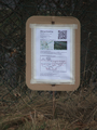
- A sign I had, of paper, card and stick,
- Emplanted in the ground for me to snap.
- Left there, to rot it would so do so quick.
- (Compared to can and tyre and sandwich wrap!)
- And so it ends: my tale; my trip; my jaunt.
- Until such time as with a GPS.
- I back, return, and revisit this haunt,
- And with bin bags shall also clear some mess...
- Apols, to all, for writing in sonnet.
- Seemed better than a page with naught onnit!
Tracklog
None available.
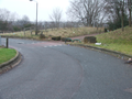
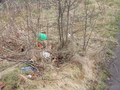
Photos
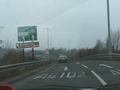
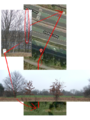
Starting the drive-by of the point
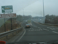
Nearly there...
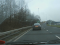
Must be in view...
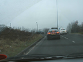
Past it.
The way of the foot
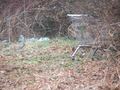
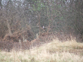
Not exactly well kept
Probably looks better in summer
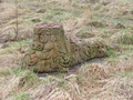
Forgotten sculpture
And another forgotten sculpture
To find the spot
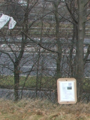
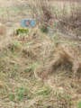
Marked, close as I could get
Should be ok
The lone witness to the endeavour


Achievements
Monty earned the Land geohash achievement
|
Monty earned the No Batteries Geohash Achievement
|