2011-03-10 48 9
| Thu 10 Mar 2011 in 48,9: 48.4491435, 9.0134634 geohashing.info google osm bing/os kml crox |
Contents
[hide]Location
In the Rammert forest near Dußlingen.
From Tübingen about 12 km by bike (on the convenient route). Nearest railway station is at Dußlingen, nearest bus stop at Ofterdingen, both about 5 km walking distance.
Participants
- Ekorren was there by bike in the afternoon.
Expedition
This was one of those "too close not to go" locations, so, despite a certain lack of time, I went. However, for just that reason I took one of the shorter and faster ways, so there isn't really anything to report on, or is there?
Went up the Steinlach valley to Dusslingen, then up into the hills and to the forest track which would take me close to the hash. This one had fooled me before: On the topographic maps of the region it's marked as a recommended cycle route, which it definitely isn't, because there's a section missing where you need to cross some nasty swamp. Hikers will find their way, a bike needs to be pushed or carried depending on the weather. However, I didn't have to go that far.
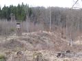
When the GPS showed about 90° off the way, I parked the bike and fought my way through debris from what once had been trees, a dense population of young trees and a significant amount of thorns. Got there in the end, and found that the trees just at the hash were actually green. Well, that's at least something different than most around them.
Went back via Kilchberg, which didn't make much of a difference. Just the strong wind that had slowed me down on the way to the hash came from the right direction this time, also the slopes were down, not up, so the way home was much faster and easier...
Gallery
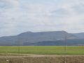
The semi-obligatory Albtrauf view
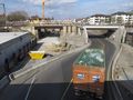
Burning another hundred millions of Euros at Dusslingen
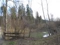
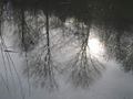
Klarasee (Clara lake), a small forest lake on the way to the hash
Almost 90 degree time
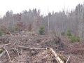
Semi obstacled terrain, but still viable
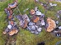
Vegetation near hash
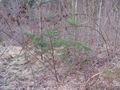
The hashpoint was marked with green trees
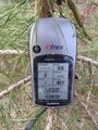
Coordinates reached


