2011-03-15 49 8
| Tue 15 Mar 2011 in 49,8: 49.2336985, 8.7853937 geohashing.info google osm bing/os kml crox |
Location
On a field close to Angelbachtal
Participants
Expedition
This expedition was a test for our planned expedition to the 48 6 graticule. We are planning to cycle from Wissembourg to the north-eastern part of the graticule, which would be a distance of about 90-100 km. We're not sure how fast we are and if we're actually able to make it this far, so we thought it would be good idea to test our constitution.
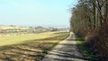
We started at fivetonsofflax's place in Heidelberg-Kirchheim and cycled southwards through a few neighbouring towns. We couldn't use GpsMid to create a route to the geohash because fivetonsofflax's cell phone is too weak for calculating routes longer than a few kilometers. Instead, we navigated using the helpful green signs indicating bicycling routes between the towns. It went surprisingly well, we had to go about 30 km instead of the shortest route of about 24 km.
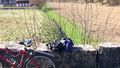
The hashpoint was about 15 meters next to our track on a field, but since there were no plants growing on it, there probably was no harm in walking a couple of steps on it. The expedition took longer than we had expected, so we decided not to cycle all the way back but to go to Sinsheim instead and take the train from there back to Heidelberg.
Tracklog
http://www.everytrail.com/view_trip.php?trip_id=1001471
Photos
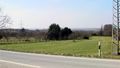
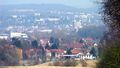
View to the Rhine valley

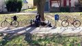
Bretzel break

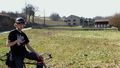

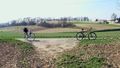
At the hashpoint
Zoom to Sinsheim


Achievements
Euterkuh and Fivetonsofflax earned the Bicycle geohash achievement
|