2011-04-03 35 -114
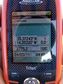
| Sun 3 Apr 2011 in Bullhead City: 35.3724286, -114.2031979 geohashing.info google osm bing/os kml crox |
Contents
[hide]Location
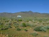
South of Chloride, Az
Participants
Expeditions
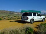
RoadRunner and I were on our way back to Tucson from a weekend canoeing trip down the Colorado River when we stopped at a roadside store for some yummy jerky (flavored dried meat) when we decided to check local geohash points. A quick U-turn had us heading back toward Chloride to find something Google labeled a road. We only had to get out and open two farm gates (with "please close gate" signs) along this "road". Eventually drove to within a hundred meters of the spot and a simple walk and GPS shuffle was all it took. Found a quicker way out through Chloride (new iPhone is really cool) and were back on the highway heading for home.
And since there's no other posting for this graticule, I guess this is ...
The Deflowering of the Bullhead City Graticule
Wyle & RoadRunner earned the Graticule Unlocked Achievement
|
which, by the way, is our 4th and possibly 5th (Nogales is still undecided) virgin graticule. Bring it on, XKCD.
PS. And HUGE kudos to RoadRunner, who's foresight was ... "I know we don't need the GPS for the river, but bring it anyway."
Bullhead City, Arizona
Bullhead City, Arizona
Bullhead City, Arizona


