2011-04-28 49 -123
Trivial hash on the side of a road near a park.
| Thu 28 Apr 2011 in 49,-123: 49.2066128, -123.1282844 geohashing.info google osm bing/os kml crox |
Location
At that little park on the side of the Oak Street bridge, on the Vancouver side.
Participants
- Wade
- Dagny - Wade & Robyn's dragalong
Plans
The geohash was so gloriously simple, in a real public park on a sunny day that the only plan posted was ...
Go there.
Expedition
Wade & Dagny
Wade programmed the coordinates into GPS, put himself and the GPS in the car. Dagney put herself and T-Rex in the car. We drove for about 15 minutes, following simple major streets for most of the way, and a few small streets for the final few hundred meters.
At the hashpoint, there was an unexpected difficulty. A car seemed to be parked exactly where we wanted to be. Wade parallel parked in front of the offending car, and was pleased to see the GPS read "0 m to destination".
After a couple of photos, we started the car back up and drove home.
Difficulty
The geohash did not require complex navigation or even getting out of the car, but it did require parallel parking. I give it a 2.5 out of 10 on the difficulty scale.
Photos
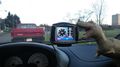
T-Rex trying to eat the GPS
