2011-05-21 28 -81
| Sat 21 May 2011 in 28,-81: 28.3363335, -81.6496377 geohashing.info google osm bing/os kml crox |
Location
In a wooded area near a small lake. Think there will be alligators?
Participants
Plans
Either here or a roadside hash North of Tampa near the coast. It's Geohashing Day!
Rhonda and Aberro started talking about plans in the early afternoon, because that was when they happened to both be in #geohashing. After discovering that they lived on opposite sides of the geohash, they made plans to meet - at Aberro's house, since he is without a car or the means to drive one. Fortunately Aberro's parents allowed him to disappear for 2 hours in the car of some crazy internet person, perhaps because he left out the "crazy internet" part of the descriptor.
Rhonda gathered a few useful geohashing items such as camera and GPS and at the last minute remembered to program the GPS with the co-ordinates as well. Based on the google street view photos, jeans and boots were part of the geohashing kit today, despite the heat.
Expedition
We drove and chatted for about 50 minutes, which is how long google suggested it would take to drive to the section of road adjacent to the hashpoint. Sure enough, there was a housing complex followed by a pond with a forest behind it, just as shown on google maps.
Unfortunately, there was no shoulder to park on. We turned around in the next housing complex access road, and only when halfway across the main road on our way to turning left, we noticed a pullout. Really, it was a blocked off demolished road, with big "road closed" signs, but there was enough space off the road for about six cars there if they parked carefully. As this was only 500m from the hashpoint, it was deemed a marvelous parking spot and we set out the rest of the way on foot. Unfortunately, only a few steps from the car, Aberro was attacked by a spider!

100m from the hashpoint exactly, we reached the mowed area around the pond and stepped off the pavement.
30m from the hashpoint exactly, we reached the closest non-bushwhacking approach to the hashpoint. As there had been no evidence of trails, this had to be our stupidity distance.
"Let's see what this underbrush is like," said Rhonda, and stepped in, even after being reminded by Aberro that it's not the alligators we had to worry about, but the wild pigs. Apparently alligators don't care about you most of the time, but pigs want you dead.
It wasn't that bad, although the boots and jeans were necessary for deflecting the plants' defenses. Rhonda found a walking stick only a few steps in and led the way, bashing plants and spiderwebs with enthusiasm so as not to end up with thorns or spiders in inappropriate places. The underbrush was dense but passable with a bit of effort and willingness to stomp on things. A long vining sort of plant with grabby tendrils every few inches trapped Rhonda about 10m from the hashpoint, and she had to back up and figure out which end of it would detach easier, as it wasn't deigning to break on being bashed with a stick. The vine then trapped Aberro as well. That was one persistent vine.
The GPS got down to 5m to destination, but our travel was slow enough that it was very confused as to which direction we should go. Rhonda checked the accuracy - 8m! great, 5m to target at 8m accuracy means we're there! Unfortunately, after turning back to the distance to target page, it showed 12m remaining. Rhonda moved about 1m forward then 1m back, then watched the distance and direction drift around randomly for a while until it showed that we were under 3m from the hashpoint. That's about as good as it was going to get.
Aberro led the way back out but declined the use of the spiderweb bashing stick and just followed our trampled path back out.
Once clear of the bushes, we performed a bug check, which inventory resulted in the discovery of two mosquito bites on Aberro's neck. Astounding that it wasn't more!
Then we drove back to Aberro's house, having an engrossing conversation on such topics as "how much do clouds weigh?". It was so engrossing that Rhonda missed the exit, took the next exit to try for a U-turn, found out they were now on a different highway entirely, took the next exit on that one to try for a U-turn, drove through a construction zone, got successfully turned around, and took the correct exit on the second try.
Photos
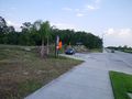
no public parking, 500m away
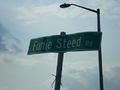
at a street with a funie name
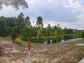
100m away
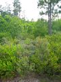
30m away...
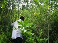
It's not as hard as it looks. Honest.
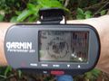
The accuracy wasn't great
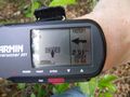
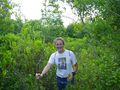
but we got there.
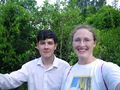
A first meetup for Aberro!
Rhonda likes hiking with a stick.


Achievements
Aberro and Rhonda earned the Meet-up achievement
|
Aberro and Rhonda earned the 2011 Geohashing Day achievement
|