2011-05-25 49 9
| Wed 25 May 2011 in Würzburg: 49.9313400, 9.9714522 geohashing.info google osm bing/os kml crox |
Location
Today's location is just north of the Arnstein Gramschatz town limit, two metres off the main road in a meadow.
Country: Germany; state: Bayern (Bavaria, EU:DE:BY); administrative region: Unterfranken; district: Würzburg rural district
Weather: Sunny
Expedition
Danatar
My planned schedule was the following: Start at 10:00, cycle the 19 km to the hashpoint arriving at 11:00-11:10, take pictures, cycle back, be home at 12:00-12:15. Then enough time to take a shower, eat and go to work.
I started at 10:05. After a short distance I found out why my rear wheel was going more difficult than usual: It was askew in its mount and was pressing against the brake. I set it right, but it kept moving back a few times when I continued until I was finally able to fasten it better. Then I cycled mostly along main roads (and the country road) on the exact route I had taken multiple times before, but only once as far as the hashpoint.
So I knew the roads and I knew the layout of the area directly around the hashpoint from looking at the satellite image. I also knew that the distance to the hashpoint was 19 km. But somehow (probably because the road at Gramschatz is called Arnstein street) I had in the back of my head that the hashpoint was next to the town of Arnstein. From the 2008 expedition to Arnstein I still remembered that I had cycled 27.5 km then, so Arnstein should be about 25 km from my place. As I had lost some time with my rear wheel and the uphill sections of the route were very difficult, I constantly checked my watch. I was later than planned and I thought I had still a large distance to go and my thoughts were going in the direction of "Going to work will be hurried" and "I'm might be a little late for work". When I arrived at Gramschatz I saw the sign "Arnstein 6 km" and thought "I'm going to be soo late for work". But I couldn't give up on Towel Day! While cycling through Gramschatz I recognized the street layout (especially the unusual double turn of the main road) and my thoughts were more like "could I be near the hashpoint after all?" I was.
I found the hashpoint easily (and very relieved) at 11:20 and proceded with the photoshooting. As it was Towel Day, both Scott and I had brought our towels. Then I started back at 11:30. The return trip was more downhill and so was much easier, I arrived at home at 12:30 with enough time to shower and go to work. Whew...
I didn't have a GPS device in 2008 but from the available roads it's clear that I passed the hashpoint on 2008-09-29.
Danatar earned the Don't Panic! Achievement
|
Danatar earned the Déjà Vu Geohash Achievement
|
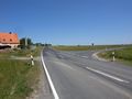
Almost there...
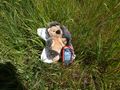
GPS, with Scott and his towel
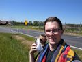
Coordinates reached! With towels!

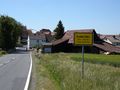
it was at Gramschatz after all


