2011-05-28 57 12
| Sat 28 May 2011 in 57,12: 57.7062971, 12.2323159 geohashing.info google osm bing/os kml crox |
Location
The forest outside of Landvetter.
Participants
Plans
Going to take the bus (Röd Express) from Gothenburg to the closest bus stop in the area (Blåklockevägen). I'll reach Blåklockevägen at 11:35 or 12:05. This is my very first time geohashing so I have some inexperienced planning to do. The real adventure begins once I'm off that bus, walking into an unfamiliar forest with nothing but my smartphone (Nokia N900).
I'm not quite sure how long it'll take me to reach the hash, but I'm guessing somewhere between 1-3 hours. I'll need to bring edibles as the place I'm going to probably doesn't have anything to eat on a Saturday (if ever). Despite the hash being some distance away from proper civilization, it looks as though there is a walkable path the entire way (thanks OpenStreetMap and contributing stranger!).
Expedition
I headed out around 10:30 AM, taking a tram to the city center. By 11.00 I was on the bus (Röd Express) feeling slightly nervous about going to a strange place for no better reason than chasing a random location. The gray clouds certainly didn't help much, promising rain later on. I was, however, excited about the fact that I found a reachable hash so soon after discovering the game (less than a week ago), and also slightly empowered by going at it all alone - I rarely leave the house alone otherwise. I was also cheered up by four cheerfully waving girls from a tram ahead of my bus. The bus driver tried to ignore the girls for a while but finally gave in, waving back with a silly little grin.
At 11:35 I got off the bus in a nice neighborhood. The houses were not brand new but the roads were, and the gardens were amazing for somebody who hasn't had a garden in years. I passed through the civilized neighborhood in less than 10 minutes, reaching a steep hill with a dirt road rather than asphalt. I started worrying that maybe the hash was located someplace high as I hadn't checked height differences at all. Maybe I was in for a long, long climb?
By 11:50 the dirt road turned into a path too small for a car to drive on, but big enough and maintained enough for a comfortable bike ride. The path also had street lights so I'm guessing it's a popular place for bikers, hikers, and dog owners. I received a text from my significant other asking about the weather, and as soon as I'd sent the "no rain yet" reply I felt the first tiny drop. Luckily it didn't actually start raining properly for a long while. The path went both up and down but was never too steep to be uncomfortable. I left the bike path around 12:05, tying a green ribbon around a tree to make sure I knew my way back later. The new path was quite un-bike friendly, as you may see on the photos.
I kept walking on the barely walkable path for some time. After 15 minutes (by 12:15) I started noticing tracks in the mud, from some really large animal. I kept my eyes open for more tracks as I kept walking, and I am now quite sure that I saw tracks from: somebody else's shoes, a dog, and an elk/moose or deer.
At 12:25 is when the panic began. There was a fork in the path. No maps I had looked at warned me about a fork at this location. Had I gone too far? Is the path new? Where am I, really? I picked up my smartphone and tried to ask my map software to clarify the situation, but it turns out technology is fairly useless once you leave civilization. I spent half an hour trying to get the phone to tell me my location, and trying to locate myself by checking Google Maps without the GPS, but no matter how much I looked I couldn't find this strange new path anywhere. By 12:50 I gave up and figured that if I keep on walking I'll reach a bigger path eventually and it'll be easier to locate myself once I find it and then head back.
It took me less than 10 minutes to find the hash once I'd started walking again. I took a few photos of the area around 13:00 (that's 1:00 PM) until I decided I was close enough to the hash. The location I was meant to find was 57.7062971, 12.2323159 but I settled for an accuracy of 57.706, 12.232. While taking the last few photos the rain was making it difficult to see any details on the screen, and as soon as I closed all the smartphone applications (maps, camera, etc) and put it back into my pocket I heard the 'low battery' signal for the first time. At that moment it felt as if the universe had held its breath to make sure I reach the destination, and once the destination was reached the universe started breathing again and all bad things happened at the same time. I hurridly took a few more photos (of a silly grin, among other things) and then started heading back. I grabbed my "lunch" (sandwich) and ate while walking. The rain let up a little bit, but still wouldn't quite leave me alone. At 13:16 I passed my "this way"-ribbon, and at 13:40 I was at the bus stop waiting to go back home. Only interesting thing that happened on the way back was two little girls asking me "are you a boy or a girl?", but seeing as my hair was tied back and hidden under a hoody and a cap, I really can't blame them. (I'm a girl, by the way).
Once I was on the bus the real rain started, and I'm now happy to spend the rest of the day indoors.
Photos
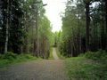
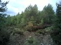
The forest walk started off easy.
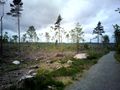
The view wasn't quite what I had imagined.
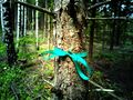
I tied a ribbon to a tree to find my way back.
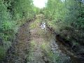
This is where the fun begins...
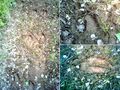
Animal tracks.. from a moose/elk, perhaps?
The Fork of Doom that wasn't supposed to exist and cost me half an hour of panic.
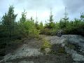
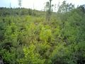
The spot is in there...
Success! This spot marks the location of 57.706, 12.232
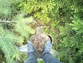
"View from the spot" or "Where did I come from?"

Nilli with a Silly Grin™ after a successful expedition.


Achievements
I would claim two awards (Land and Public transport) but as I don't have sufficient proof for any of them I'll do without. I've got date and location in the meta-data of the photo for the Land award, but forgot to take pictures of the bus.