2011-06-17 48 9
| Fri 17 Jun 2011 in 48,9: 48.5741786, 9.6052638 geohashing.info google osm bing/os kml crox |
Location
A field/meadow on the Bläsiberg, just off the A8 near Wiesensteig.
Participants
Plans
I'm driving to Ulm, need to go by car unfortunately. If my spare time doesn't get eaten by traffic, I'll get off the A8 and visit the hash at about 11.
Expedition
Starting about 90 minutes earlier than google routing suggested was neccessary, Hijackal decides to take the (slower) road through the Höllental - a great decision. With such interesting surroundings, even driving all alone in a car can be entertaining. (No pictures though... a disadvantage of this means of transportation)
As Hijackal approaches the highway exit closest to the hash, he still has about 70 minutes of spare time: commence detour, hashing it is. The car is parked about 300 m from Hash Meadow, with the top of the Bläsiberg exactly on the straight line to the hash. The very top is covered by a forest - suprisingly dark considering it's almost noon. Soon after passing the highest point, the end of the forest comes into view, allowing first glimpses of Hash Meadow.
The hash location itself is rather boring, and time is running faster than expected - I don't have time for finding something more interesting here. This instance of car hashing is even less satisfying than expected.
On the way back to the Autobahn, Hijackal drives through Wiesensteig. About half of the village seem busy sweeping the sidewalk in front of their houses.
P.S. Hijackal makes it to his rendezvous point north of Ulm exactly on time. Someone else misses their train, though. Hijackal waits.
Photos
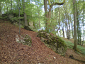
The top of the Blasiberg - I'm almost there!
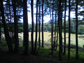
I can see daylight! (and probably the hash somwhere between the trees on the left)
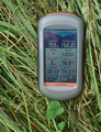
Yay!
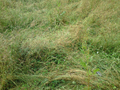
Yes, there is more than grass in this picture.


Achievements
Hijackal earned the Land geohash achievement
|