2011-06-19 46 7
| Sun 19 Jun 2011 in 46,7: 46.2648826, 7.3809181 geohashing.info google osm bing/os kml crox |
Contents
[hide]Location
The geohash is located directly on a street (named Route d'Arbaz) between Sion (canton Valais) and Le Lazier.
Participants
TheOneRing - by public transport.
The Expedition
TheOneRing
The weather in Berne was really bad so I checked the geohash locations and the weather forecasts for them. Sion seemed quite easy to reach and the geohash looked not very far away from the city. I haven't been in Sion before, which was a good reason to go there.
I reached Sion around half past 11 and started my way up. Looking at my eTrex I saw that it was 4.5km as the bird flies. The way was quite steep sometimes and even the serpentines didn't make it better. But the view down in the valley of the river Rhône compensated everything. I crossed several vineyards. In the end after 5.9km I reached the geohash, which was less than expected. And again, the view was magnificant. The total difference in altitude was more than 460m, which means 78m per kilometer in average. I took the usual photographs, exhausted and sweating.
On my way back I took more photos of the countryside, amongst others for some panoramas. A prominent point is the hill Tourbillon with the Château de Tourbillon, now a ruin. I completed my tour through the city and took a train back to Berne.
Photos
TheOneRing
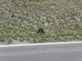
My rucksack marks the geohash
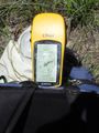
Proof that I reched the right coordinates...
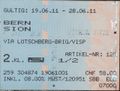
...on the right date

Exhausted, sweating, but happy self shot
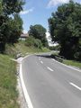
View along the street
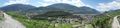
Panorama of the valley with Sion
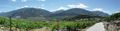
Panorama of another part of the valley
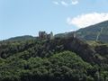
The Tourbillon with the ruin of a palace
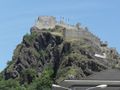
Again, but different viewing angle


Achievements
TheOneRing earned the Land geohash achievement
|
TheOneRing earned the Public transport geohash achievement
|