2011-07-05 28 -13
| Tue 5 Jul 2011 in 28,-13: 28.6815181, -13.8386405 geohashing.info google osm bing/os kml crox |
Location
Near the north-east coast of Fuerteventura. We've never been there but from Google maps it looks like its a desert with lots of dunes.
Participants
Plans
Mampfred and LadyBB are on holiday in Lanzarote. Technically it's even their honeymoon as they haven't had any holiday after marrying some 18 months ago. Of course, we've seen some great example recently how you deflower graticules on your honeymoon recently so we thought we'll also give it a go.
We've got a hired car and the permission to use the ferry to the next island, from there it should be a short drive and a little longer hike through the desert. We'll see how it goes from there ...
Expedition
One of our coolest expeditions eva - from our point of view anyway!
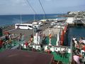
We booked the ferry in advance and decided to for the 10am as we're still on holiday and didn't want to get up too early. Still, getting the ferry at Playa Blanca at 10am meant to be at the harbor around 8:30am with a half hour drive after breakfast. Plan worked out nicely, we put the car in the queue and while waiting did one of the many geocaches on the island ;)
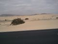
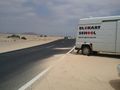
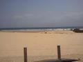
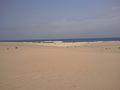
We arrived on Fuerteventura around 10:40am and headed straight for the coastal street that would pass the hash by a couple of hundred meters. We had a beautiful view along the way, the beaches in the north are just amazing while on the other side of the street there's desert and hills far away (also it's a national park apparently). Unfortunately there wasn't a carpark near to were we planned to enter the desert so we had to park a little further away.
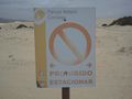
Opposite the parking area we spotted some strange signs which we couldn't quite translate due to our seriously rubbish spanish. They said "Prohibido Estacionar" which we initially translated to "do not enter" due to it being a national park. That got us worried as there was lots of local police on the streets and we really wanted to save the police geohash for some other time. Internet on the phone wasn't working so we quickly texted some friends in germany and asked for a proper translation. A couple of minutes later we were told that it essentially means "no parking" on the desert side of the street. We were very relieved - thank god for social networking in any possible form :)
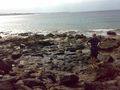
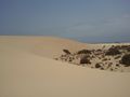
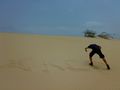
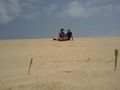
So we put on our hiking shoes, grabbed cameras and water and headed for the hash. For us it was an amazing and wonderful walk (for less than 1km though) as we've never walked through a desert before. The hash was easily located and we had a bit of fun with drawing XKCD in the sand. When the fun was over and the sun still relentlessly shining upon us, we decided to head back and see some more of Fuerteventura before taking the evening ferry back to Lanzarote.
One more thing: being german we were quite surprised when we spotted a Lidl sign in Puerto del Rosario (Lidl is a typical german supermarket). We simply had to follow it and it took us through half the city for a couple of kilometers before we finally stood in front of closed doors due to renovations (see photo). Unfortunately we won't be on the island for the grand reopening ...
Yay for honeymoon-hashing, there should be an achievement for this :)
Tracklog
See here.
Photos
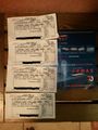
Got our tickets for the ferry ready.
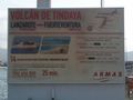
Sign of the ferry company.
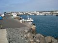
View of the harbor.
The route of the ferry.
Mampfred in front of the cache waiting for a muggle-free time.
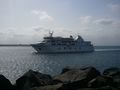
The ferry aproaching.

LadyBB waiting for the ferry.
View from the ferry.
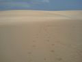
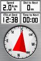
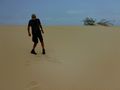
Hash should be this way.
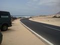
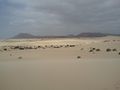
The street next to the hash.
Oh oh ...
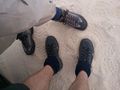
Hash shoes.
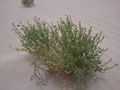
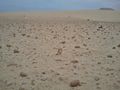
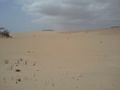
Life in the desert (note the bee top left)
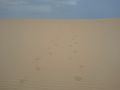
Hash tracks in the sand.
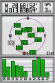
Coordinates ...
... reached.
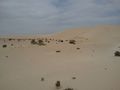
View at the hash.
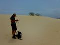
Mampfred at the hash.
X ...
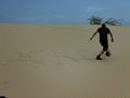
... XKC ...
... XKCD ...
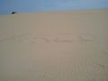
... Done!
XKCD with hashers.

Stupid grin.

Cool, a Lidl!
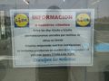
It's closed though :(


Achievements
LadyBB (+MJ) and Mampfred earned the Land geohash achievement
|
LadyBB (+MJ) and Mampfred earned the Graticule Unlocked Achievement
|