2011-07-10 50 5
| Sun 10 Jul 2011 in 50,5: 50.7843653, 5.7574758 geohashing.info google osm bing/os kml crox |
Location
According to Google, the location is on a field behind a house.
Participants
Plans
Because of the circumstances TFTD decided to take this one by bike on his own.
Expedition
Since yesterday has been a pretty quick activity I decided, after seeing that todays hash is within biking distance, to go for it. Unfortunately I don't have any GPS device, neither a camera so I can't provide any pictures.
As preparation I looked for a nice route, printed some maps of the way and a google-maps picture of the target area. The hash seemed to be on private property and I decided to deal with it, when reaching the destination. Because it was supposed to rain in the evening I started my journey at noon. OpenStreetMaps predicted a trip time of 3 hours so I calculated with 4 (which turned out to be pretty good).
The way to the designated hashpoint was unspectacular. Once I asked an older man, if I still was on the right path, besides that, the Netherlands have nice bike ways almost everywhere. At one point a horde of Mofas (kind of motorcycles) came directly into my direction. Probably more then 50 with young looking people on them. Maybe they celebrated that they had no more school or something like that. I reached the destination and things looked a little bit different than one google maps. That targeted field had more trees on them, and it seemed the camping ground was also extended. Unfortunately none of the campers neither the owners of the place were home. After some thinking I decided to jump the fence, and with the help of the trees and my printout I moved to the hashpoint. After staying their for a couple seconds I decided to move away, so nobody would be mad with me. Also the weather got worse and the clouds were already pretty close, I decided to take a quick break on a bench, eat something and start my journey back.
Because I was also close to Belgium I wanted to go their and be able to say I traveled 3 countries to reach the hashpoint. Shortly after leaving the main roads I congratulated myself again to my decision 10 years ago, to equip my bike with off-road capable tires (and hating myself for not buying guards and I don't have suspension forks). It got wet, narrow and sometimes trees were laying across the way. I managed to get 3 little wounds, my lower legs touched by stining-nettles and myself wet and dirty. This part probably cost me the most time, but I was happy to get thru without breaking myself or my bike (I didn't take any repair stuff with me).
After managing that I decided to stay more on main roads but I missed the right way at one point and took a short detour. Now besides the roads being good again a lot of up and downhill started. Additional to that the traffic got more dense. In this area seemed to be some festival, because everywhere I saw carriages and tons of people. After being about two thirds into the way back it finally started raining a little but I could avoid most of it by taking a way thru the woods. After this last hill I enjoyed another nice rolling down the hill and only had some last kilometers thru the city to go. The way back roughly took me 2.5 hours.
Tracklog
Photos
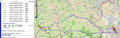
Roughly the way I cycled.
Achievements
Hm do I get any?
- Well yes, you get the Land Geohash achievement ;) - Mampfred 16:59, 9 March 2012 (EST)