2011-08-06 42 -88
| Sat 6 Aug 2011 in 42,-88: 42.9349782, -88.4725153 geohashing.info google osm bing/os kml crox |
Location
A woodsy area just outside Ottawa Lake Campgrounds. It's even within a couple hundred feet of a parking area.
Participants
- RocketMac - My first geohash. Despite the tale below, it won't be my last.
Plans
I have been wanting to try geohashing for a long time. At the start of the year I vowed that I would go the first time the Saturday meetup met the following conditions:
- It's within an hour drive
- It's someplace I can get with relative ease (remember this would be my first)
- I can get away for two or three hours on a Saturday
So when this came up on a day my wife was going to be working all day and was mere yards from a parking lot at a state park and less than a tenth of a mile from a geocache as well!? ... I just had to try it!
Expedition
I had planned to leave the house at 1500 so I would have time to make the 40 minute drive and get to the spot with time to spare. Sadly, some last minute items kept me from leaving until almost 1530 instead. I made up quite a bit of time on the road, but I still pulled into the parking lot 200 feet from the cache at exactly 1600 hours.
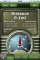
I took off down the trail and as soon as I was at a direct right angle from the hash point, I went in. There was quite a bit of bushwhacking to do and the tree cover was driving my GPS nuts. After a while I realized I had walked right through the spot a few times so I stopped and made a screen capture (forgot to take a picture of myself) or two of my GPS and called it a victory.
Now I was only less than a tenth of a mile from the geocache GC1JTJN - Sweet Smelling Land and started my way there.
That is where things went wrong...
I followed the age old cliche, "the shortest distance between two points is a straight line" and started hacking my way to what appeared to be an open space ahead that surely would be where the cache is. I was very wrong.
In retrospect I should have gone back out to the trail with the realization that while geohashes are completely random and don't conform to things like trails and walking paths, geocaches generally do. Instead I forged on and after many many bug bites, bruises and scrapes I reached a stream. The area on either side was muddy and I wasn't going to be able to jump it, so I walked a little ways down and used a three inch thick downed tree branch as a bridge with the overhead limbs as hand-holds. I made it safely and continued on my way. ...into the deep mud.
I had been walking through some leafy overgrowth when I felt the ground get soggy and then a step later my foot sunk into the mud halfway up my calf. Fearing the loss of a shoe, I slowly pulled up until my other foot started sinking. Pulling on a tree, I managed to get my shallow foot free and shifted my weight until I could get my deeper leg (and shoe) free.
Now it was time to take another GPS reading. I wasn't getting much closer and I couldn't determine how to proceed. About ready to give up, I made my way back to the creek and followed its edge back to the trail!
*WHEW*
I was in a foul mood now. This had taken three times longer than I expected or that it should have. My shoes were destroyed. I was covered in dirt, mud, scratches, bug bites and now even more bugs were dive-bombing my hair. I had come this far and I was not giving up!
From here I just followed the path to a couple dozen feet and a smaller path led off the main path right to an obvious cache hiding spot... and there was a 30cal ammo box just waiting for me!
As I signed the cache log, I looked down to see over two dozen mosquitos on my clothes trying to get through to my skin and some were succeeding. I closed up, made it back to the path, and walked back to my car.
With the air conditioning kicking in, I logged the geocache find and started home. I was muddy, my socks were soggy, I was bleeding a little and covered in bites that were starting to itch. It was, by far, the most disasterous outing of my life.
I can't wait for the next one!
Photos
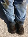
So much for these shoes
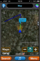
Surely I walked through the spot by now!
Now on to the cache
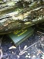
Victory!


Achievements
RocketMac earned the Land geohash achievement
|
RocketMac earned the Hash collision achievement
|