2011-09-11 47 7
| Sun 11 Sep 2011 in 47,7: 47.3321399, 7.9189641 geohashing.info google osm bing/os kml crox |
Contents
Location
The geohash is near Olten (canton Solothurn). When walking on the street to the Säli Schlössli (Säli castle) one passes the geohash which is approx. 25m inside the forest.
Participants
TheOneRing - by train and walking.
Trivia
Interesting side remark: although both Olten and the Säli Schlössli lie in canton Solothurn, a part of the way and the geohash lie in canton Aargau, shown by an image in the photos section.
The Expedition
TheOneRing
I went by train to Olten quite early this morning, because the weather forecast said something about rain and thunderstorms this afternoon. So, I could start already half past nine from the station. From the map I could read that it would be about 3.5km and 200m in altitude. But then a 'tragedy' in three acts began.
First try: I was walking on the street until the supposed point where I should turn and walk into the forest. The distance was more than the map showed and I started to wonder. Earlier I saw a trail which might lead me closer to the geohash. It turned out not to be true and being puzzled I checked my eTrex with the coordinates. And surprise, surprise: I programmed the wrong coordinates; instead of typing 47°19.928' in latitude I wrote 47°19.982'. After correcting I walked back to the street and started my second try.
Second try: When I was again near the point where I turned around, it was still 25m ... steep uphill and through thick forest. Quite impossible so far. But the day was too nice to be upset and I went on to the Säli Schlössli. I took a break to drink a Hot Ovomaltine and to take a first set of photographs.
Third try: Well, time to start the descent. Before that, I visited the ruin of another castle on that mountain, the Alt Wartburg. They were built vis-à-vis, but from the same lord of the castle. Surprisingly, I saw some of wildlife dragons in Switzerland and took photos, of course. For my third try I chose a way which led me above the geohash, to be hopefully luckier. But it was somehow disappointing, because there was also no way through, I did not come closer than 35m to the geohash.
There was no possibilty to reach the geohash without a machete, I aborted the mission and walked back to Olten. Nevertheless it was a nice trip and the view over Olten and its surroundings was very impressive.
Photos
TheOneRing
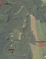
The way to the geohash and the canton border
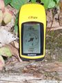
Second try: 25m ...
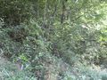
...this way
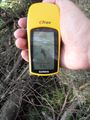
Third try: 35m ...
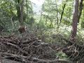
...this way
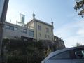
The Säli Schlössli
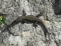
A dragon at the ruin


Probably more to come, some panoramas under construction.
Consolidation prizes
TheOneRing earned the Done with Nature consolation prize
|