2011-09-16 43 -119

| Fri 16 Sep 2011 in 43,-119: 43.2130838, -119.2013075 geohashing.info google osm bing/os kml crox |
Location
In ranchland on the south shore of Harney Lake.
Participants
Expedition
Although Google Maps was all too blithe about sending me to this hashpoint -- g'wan! it's right on a road! -- I knew going in that it was a long shot. In this part of the world, you can't really be sure that what looks like a road on the map is really going to be a road unless it has a state or federal number. And in the event, it turned out to be two hours of futility and isolated rural splendor, in three acts.
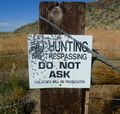
I: Google Maps wanted me to take an incredibly convoluted series of roads off of state highway 205. I rolled my eyes at this, but Weaver Springs Road turned out to be not only accessible but paved, and I flew westward across irrigated farmland until the pavement ran out very suddenly at a ranch entrance. Would the good folks of the Rattlesnake Creek Ranch mind if I used their access road? Apparently they would; they had scattered some of the least friendly trespassing postings I've seen. Back to the main road.

II: The second option was to try South Harney Road, nominally the "road" that the hashpoint is on. This started off as a smooth, well-graveled surface, but I was still ten miles from the hashpoint when a combination of rutting and a sandy surface -- a bad combination for the Geohashing Expedition Vehicle, which is two-wheel drive and doesn't carry much weight on its rear axle. Back to the main road.
III: The third option was a spur-of-the-moment affair, following a gravel road, Double OO Road, that I had noticed when schlepping between Weaver Springs and South Harney. It turned out to be beautifully surfaced, and I flew west through the soft golds and greens and under the huge green-blue sky at a good 60 mph. Harney Lake, a shallow basin that expands and contracts dramatically depending on the season and the year, was quite full, lending a rich healthy marsh stink to the proceedings.
Fourteen miles brought me west of the lake, and I was able to turn south on a good road that brought me to rolling hills at the southeast shore. The road started to deteriorate here, but continued quite reasonably until, to my surprise, in landed me in what appeared to be the front yard of a ranch compound. Assuming I'm right, someone is living a very isolated existence indeed, almost an hour from the nearest store where you could buy so much as a Hershey Bar. At this point, I was still 2.3 miles from the hashpoint. The ongoing road was deeply rutted and not very public-looking, and there was a dust cloud coming my way that marked a ranch vehicle that would obviously be taking up both ruts. Feeling isolated and disinclined for a hike, I decided that enough effort had been thrown into 2011-09-16 43 -119. I never got within two miles of the hashpoint, but I saw a lot of beautiful ranchland, farmland, and marshland on a spectacular late-summer morning.
Expedition Thrice-Thwarted.
Photos
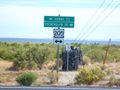
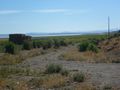
The theater of operations for this expedition was a long way from anywhere.
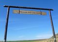
The first attempt ends at Rattlesnake Creek Ranch.
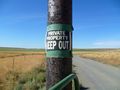
Not especially welcoming.
Not welcoming at all, actually.
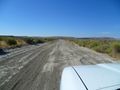
The second attempt ends when the road gets troubling...
And the third attempt ends when the road gets downright nasty.
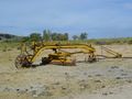
This old tractor-drawn road grader was quietly decaying in the sagebrush..
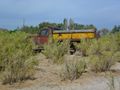
As was this old truck.


Achievements
- This was the first known attempt to hash the Hines graticule.
- Third Expedition of the Endurance Geohashing series.
Michael5000 earned the No trespassing consolation prize
|