2011-09-17 45 9

| Sat 17 Sep 2011 in 45,9: 45.7586070, 9.8922134 geohashing.info google osm bing/os kml crox |
Location
The hash was near the Endine lake, not far from Bergamo and therefore feasible with my bike. Unfortunately I live on the other side of the hills surrounding the lake, so I knew that this geohash would have required a lot of time and energy.
Participants
- tankmiche from Bergamo.
Plans
The plans were to start somehow early with a lot of water and something to eat to hurry to the top of the hill (I've done it before, it shouldn't be so hard). Once there, the geohash would be somewhere about 6-7km downhill; then, I would calmly come home taking the (longer but flat) road around the hills.
Expedition
Not half a kilometer has passed when I remember one, slightly fundamental detail: I had already done the road uphill all the way to the top, but that was around 4 years ago. I haven't really seriously used the bike since then. But nevermind! I can still do it, I'm young, healthy and... wait, the road wasn't this steep the other times! I might need a break.
After a non-trivial number of breaks, I reach Colle Gallo (literally Rooster Hill), with its famous Lady of Cyclists sanctuary (that's not a joke). The geohash is on the other side of the hill, somewhere near the road. I start my GPS, it usually takes some minutes before it finds my position. From there, the road downhill is a rather refreshing change (except for the navigators screaming in my ears thanks to the headphones).
The geohash lies in a steep field near a secondary road. First I get to a no-trespassing fence, but then I find a path in the grass right below it, which leads directly to the geohash. It's a fairly nice spot, if not for the high grass and stinging plants. But then again, the view is very nice. Snack time!
It's time to head back home, and I climb the field to reach the road. I continue descending nearly arriving at the Endine lake, but the road around the mountains is way too long and I've yet a bit of energy with me, so I take another path through the hills (somehow softer) and get quickly home.
Photos
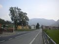
Over the hills, but not far away
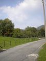
The road uphill must be getting steeper and steeper, I tell you.
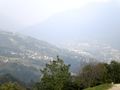
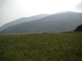
The view from Rooster Hill. You can see the Endine Lake down there.
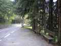
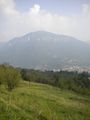
The descent after Rooster Hill
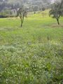
Oh geohash, you so silly
The view from the geohash. Perfect for a picnic!
The view from the geohash. The lake is down there somewhere...
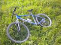
The bike of my adventure


Achievements
tankmiche earned the Picnic achievement
|
tankmiche earned the Bicycle geohash achievement
|