2011-09-20 44 -121
| Tue 20 Sep 2011 in 44,-121: 44.1135261, -121.0385805 geohashing.info google osm bing/os kml crox |

Location
Near the Alfalfa settlement east of Bend.
Participants
Expedition
On Google Maps, reaching this hashpoint is a simple matter of driving out to the Alfalfa settlement, turning off on a country lane, crossing an irrigation canal on a bridge, and strolling up to the point. The trouble in situ is that the lane doesn't exist. Aerial imagery suggests that the bridge is actually there, but without the lane it's a bit of a moot point.
I attempted to walk in from the northeast. I climbed up a rough shelf and across some sage desert to the canal, which to my surprise was an impressive rushing, roaring thing. I followed it as far as I could until it reached fenced fields, leaving me still about a mile from the hashpoint.
I also attempted to walk in from the southwest. I reached fencelines at about two miles out.
I pretty much circled the hashpoint looking for other means of ingress. All in all, in fact, I spent about two hours worrying at this random point. And then I gave up and headed for home.
Photos
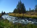
What I thought would be a little jump-across ditch turned out to be a roaring torrent!
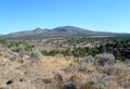
Looking off of the plateau towards the fields. The truck is just visible down by the road.

Achievements
- Thirteenth Expedition of the Endurance Geohashing series.
- My first attempt at Deschutes County.
Michael5000 earned the My kingdom for a boat consolation prize
|