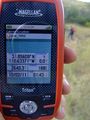
2011-10-02 31 -110
| Sun 2 Oct 2011 in Nogales: 31.8560839, -110.6337055 geohashing.info google osm bing/os kml crox |
Location
Empire Mountains north of Sonita
Participants
Expeditions
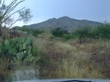
First time in the area of the Empire Mountains. Looks like a great off road adventure with a short half mile hike. Satellite pics and Google Map roads are quite different, so there will be some "seat of the pants" navigation. :)
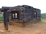
Stopped to explore a former cowboy bunk house along the way (from the outside - no trespassing). Managed the normal plethora of vegetation that scratches, pokes, and stabs hikers to get to the geohash point. Short and sweet views of lots of lightening surrounding the area. When the wind and rain started to pick up a bit, we decided it was time to relocate closer to the car. Good timing as the real rain started just as we got back. Proceeded to picnic in the back of the SUV with the liftgate up, the rain coming down, the ants scurrying underground, and the lightning flashing. Another great afternoon.
Biggest laugh was on the way out. We actually drove further forward looking for a place to turn around and there it was. Beside the "bump and grind" jeep trail (enlarge the last picture) and 5 miles away from the nearest pavement - a realty sign for any passers-by who happened to be interested in buying the property.
Nogales, Arizona
Nogales, Arizona

Nogales, Arizona

Nogales, Arizona
Nogales, Arizona


