2011-10-09 49 8
| Sun 9 Oct 2011 in 49,8: 49.4032732, 8.6177873 geohashing.info google osm bing/os kml crox |
Contents
[hide]Location
On a field near Carl-Coerderler-Straße in Eppelheim
Participants
Expedition
After weeks of checking the haspoint every day it finally came very close to my house. Perfect for a first expedition to test my equipment and to get used to geohashing. I got on my bike, put the mobile phone with the GPS program in its holder on my handlebar and started my first expedition. Due to some communication problems between my GPS program and me, we had to take a little break in Eppelheim and I had to tell my program how it should show me the road I'd have to follow. We got an agreement and I went on. On my way I came across a house that burned down several years ago. I was there to report for our local broadcast "Radio Regenbogen". I totally forgot about that place. It looks pretty nice now, I guess the insurance payed. The hash point was next to a development area and I got pretty close to it, but I had to drive around the corner and get off the bike to reach it. I was pretty lucky: First, the backyards of the houses were pretty small so they couldn't get in the way. Second: There was an area with a big metal fence, but it ended about 5 metres away from the hashpoint. And third: The field with the hash point was not planted. On my way back I decided to do some more exploration as I haven't seen much of Eppelheim so far. I got totally lost but then discovered some helpful signs for cyclists and got back to an area where I knew where to go. My equipment works well and I'm ready to do bigger expeditions now.
Photos
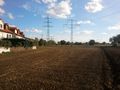
View to the hashpoint

The big fence that almost ruined the expedition


Achievements
Karl_77 earned the Land geohash achievement
|
Karl_77 earned the Bicycle geohash achievement
|