2011-10-09 50 8
| Sun 9 Oct 2011 in 50,8: 50.4032732, 8.6177873 geohashing.info google osm bing/os kml crox |
Location
Outside Hoch-Weisel in a drainage ditch between a field and a field road, quite easily accessible.
Participants
Plans
Drive to the end of the village, walk a couple of hundred meters.
Expedition
Of course, there was various roadworks in progress so noone not from the village could find a way (not me, at least), so we went there over some apple orchards (and cherry, and pear...) and past some cows from a point a bit more to the southend of the village. Apart from the hash dance, nothing interesting, but a very nice landscape on a sunny day. Shame I forgot to install the hash poster somewhere, it would probably have been noted, there were plenty other walkers enjoying the weather.
2km further there was the Hausbergturm (~Homemountain tower) which we then hiked to through the woods. It was erected for Hessentag in Butzbach some years ago (sort of a federal fair wandering between towns from year to year) and provides the conqueror of stairs with a nice view over Butzbach and the surrounding territory. All in all, a nice time in the coutryside. :-)
Photos
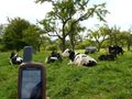
Some cows on the way to the hash point.

A sudden moment of darkness on an otherwise beautiful day.
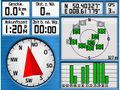
Yup, got there.

Mandatory?
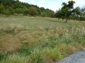
Hash point about 5m in front in the grassy ditch.
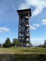
Hausburgturm, interesting wood construction. Every construction part is inscribed with its sponsor.
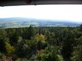
Panorama view from the tower, the hash point is approx. in the middle behind the forest.


Achievements
Rincewind and Yakamoz earned the Land geohash achievement
|