2011-10-16 45 -122
| Sun 16 Oct 2011 in 45,-122: 45.5873205, -122.3561470 geohashing.info google osm bing/os kml crox |
Location
Washougal, WA
Participants
Plans
Once the day starts I think that I'll drive down WA 14..
Expedition
I made it, with an easy walk down to the hash, with the exact spot in the middle of briars and brambles. Once again I emerge covered in weed seed. As I thought, the blue on the google map was a dry (until the rain starts) overflow channel of the river that I could walk in. I hung a little yellow marker at the spot, as I do. It will be nice to see if someone else's GPS agrees with mine. I lucked into parking by the easy climb down to the weed patch.
Tracklog
Photos
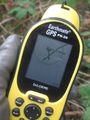
When it gets inside the 20 ft circle it drifts as fast as I can walk.
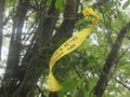
The basic crepepaper "I was here".
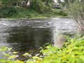
The water is over here, despite what Google maps says.

It's so hard to get the exposure right when the camera's laying on the ground.
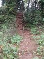
I slid down the hill, but found this somewhat funky stairway back up.


