2011-10-20 43 -79
| Thu 20 Oct 2011 in 43,-79: 43.1416168, -79.9349289 geohashing.info google osm bing/os kml crox |
Participants
Plans
The geohash was somewhere out in a field somewhere, inaccessible I'm certain. So, I decided to do some Decihashing instead.
Expedition
From work, the first spot I visited was at Bathurst, just north of Hwy. 401, at Edinburgh. The street was a bit busy, but luckily I was able to get a good reading on the sidewalk.
From there, I hopped back on the highway, and drove out to Mississauga. I had been to this area before, way before, on a drive for a job I had back in 2001. I parked in a company parking lot around the corner, and got the point that was just on the street. I was able to get a picture from the gutter. The area hasn't changed that much. I ended up stopping for a bite to eat at the A&W at the corner of Dixie and Aerowood.
Lastly, the final point appeared to be on the road on Jane between Major MacKenzie and Rutherford in Maple, just off of Hwy. 400. If Canada's Wonderland was open, I would have stopped for the 'Halloween Haunt.' It wasn't. I need to go back there... So, I don't have a picture of my GPS while driving through the point (that would be dangerous!) so I took a track, of my whole trip, including the drive through the final point.
Tracklog
I uploaded the track here: [1]
Photos
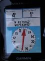
On target.
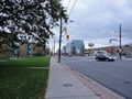
A shot of Bathurst.
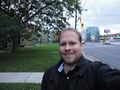
A shot of me.
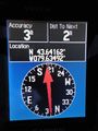
Zero'd in.
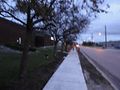
A little into dusk in Mississauga.

A little smile.


