2011-11-26 49 8
| Sat 26 Nov 2011 in 49,8: 49.3244698, 8.8723498 geohashing.info google osm bing/os kml crox |
Contents
[hide]Location
On a Hill in Eschelbronn
Participant
Expedition
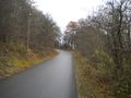
Been there, seen it, done it. A rather short expedition without any problems or special events. I took a train from Heidelberg mainstation to Meckesheim where I changed into another train to Eschelbronn. Both trains were as good as empty. From the station in Eschelbronn I walked the remaining 300 meters to the hash point. The road was pretty steep and suddenly I came across a very steep hill with a lot of trees. I decided to climb on it and reached the other end without any problems. There I discovered that a path would have let all around the steep hill. But eh, geohashing is supposed to be an adventure where you have to do more than just walking on paths, isn't it? I reached the hash point and saw that there would have been a very nice view - if all those trees and brushwood wouldn't be there. So I decided to walk around the hash point and found a beautiful landscape. I took some pictures and left. My way back took longer than expected: The display in Meckesheim first announced a delay of 5 minutes, then 10, then 15. Finally the train came. This time I wasn't alone in there, I noticed I was going back to civilisation. ;) All in all a pretty neat expedition with a nice view in Eschelbronn.
Tracklog
http://www.everytrail.com/view_trip.php?trip_id=1371802
(The missing part is the tunnel under the "Königsstuhl", the mountain with the castle of Heidelberg on it.)
Photos
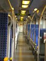
A whole train just for me.
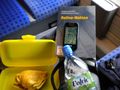
Geohashing equipment: Water, cheese pancakes, mobile phone with Geohash Droid, an interesting book
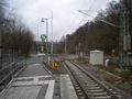
Eschelbronn station. Only one track, and only the S51 drives on it.
"Life is just a slow train, crawling up a hill"
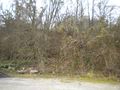
Hill -vs- Karl_77: Karl_77 wins!
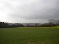
View to the hashpoint
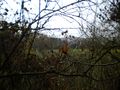
Autumn looks beautiful in Eschelbronn!
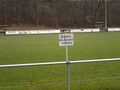
A football ground near the hashpoint. The sign says: "Keep off the grass!" I wonder how the players manage to play there. Maybe they do Quidditch in Eschelbronn.


