2011-12-05 43 -89
| Mon 5 Dec 2011 in 43,-89: 43.5323692, -89.6939114 geohashing.info google osm bing/os kml crox |
Location
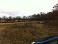
A tree-line near a cemetery in the Wisconsin Dells.
Participants
- RocketMac - On the way from MKE -> MSP
Plans
I was spending another week in Minneapolis for work and decided to check the day's hashpoints to see if I could recreate my previous multihash run or, at least, add another hashpoint or two to my belt along the way.
Expedition
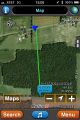
Of all the graticules I'd be driving through, only one was within a reasonable distance of the route. A quick scan of the map showed one within a decent distance of a road near a treeline and near a cemetery.
When I got there, I realized it was a good lesson in "map scale".
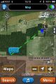
The closest point put me straight back from the hashpoint but straight through a quarter mile of wooded area but only before a quarter mile of recently cleared crop land.
I knew there was a cemetery nearby, so I decided to park there and work my way behind the wooded area. The "road" to the cemetery was mostly sand and I was getting worried about getting stuck. Then when I got to the top of the hill, I saw the lines and lines and lines of rope with "caution" tape wrapped up in places.
If I really wanted to get there, I could have, but now I was really behind and cold. It was time to pass and get back on the road.
Just as I turned around and my tires lost traction in the sand. I wondered what AAA would do about this, but I dropped gears and eased it forward. Whew!
Photos

The Stupid Grimace
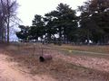
The first spot
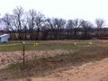
Second spot
Caution tape
More caution tape
And more tape


Achievements
RocketMac earned the Prize poultry Consolation Prize
|