2011-12-08 43 -89
| Thu 8 Dec 2011 in 43,-89: 43.5865754, -89.5954714 geohashing.info google osm bing/os kml crox |
Location
A small rural road just off Highway 16 near the Wisconsin Dells.
Participants
RocketMac - Heading home from Minneapolis to Milwaukee.
Plans
My wife and I visited the Dells last Thanksgiving just to get away. One of our stops was Moosejaw Pizza and Brewery where we bought a couple growlers of beer. I've driven between MKE and MSP several times this year and always meant to bring those empty growlers with me to get refilled.
When I checked today's coordinates, I was disappointed that I would probably only get one hashpoint or maybe two on the route. When I looked at the map, I was happy. The hashpoint is not at all far out of my way after stopping at Moosejaw to get back home.
Expedition
Class got out over an hour early, so I was able to get on the road and minimize traffic coming out of the twin cities.
Instead of my usual stops for geocaches along the way, I drove straight from Minneapolis to the Dells. I pulled into Moosejaw for dinner and reloading the growlers.
I had planned on stopping for a geocache but when I got to the road it was supposed to be on... didn't exist. Looked like it been taken out somewhat recently, but it was not going to be safe to drive. The cache was about a tenth of a mile away, so I could have walked; but it was cold and I decided to pass.
The last half mile to the hash was nice and quiet. I got to the point and pulled right onto it.
After grabbing a picture (from inside my warm car) and some captures, it was time to move on.
Tracklog
My log is available in GPX and KMZ formats
Photos

Stupid Grin
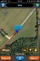
GPS Map
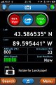
GPS Loc
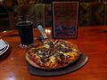
Pizza and Beer


Achievements
RocketMac earned the Land geohash achievement
|