2011-12-11 42 -87
| Sun 11 Dec 2011 in 42,-87: 42.0252033, -87.7043083 geohashing.info google osm bing/os kml crox |
Location
The first baseline of a nice park in Evanston, IL with a sled hill.
Participants
RocketMac - A slight detour (44.6 miles) to visiting friends in Oakwood Hills.
Plans
Both the 42,-88 and 42,-87 graticules were possible detours to spend the day with friends, but this one I had not yet visited. Normally, I leave the house at 10am to visit friends at noon once a month, but this time I left an hour early to make the hashpoint with time to make it.
Expedition
My wife and I have turned Sunday mornings into a tradition that includes spending an hour or two at our favorite coffeehouse with our Kindles, iPads, or laptops and enjoying coffee and scones. Additionally, I am in an Exalted RPG one Sunday a month. This normally goes just fine and I leave around 10am to make a noon game. Today, however, there was a previously unexplored (by me) graticule in a hashpoint that is mostly lake. I couldn't resist and left even earlier to make this hour detour.
The drive, itself, was straightforward and I arrived at the park with the hashpoint with plenty of time to spare. As I crossed the frozen dirt of the baseball diamond to make the hashpoint around first base, I saw these large and odd bird tracks. Considering the XKCD love of velociraptors, this made me smile!
As I walked the baseline waiting for my stupid GPS app to update and show I was standing on the point, I thought, "Huh! I bet there is at least one geocache nearby." I checked and there was one! (GC349X9 - Adventures of the P^2’s – Part 2) It was a little outside the 0.1 mile (528 feet) range I consider to be close enough, but I should go and find it. It was at the top of the sled hill. As I climbed the hill, there were several signs saying that it was "private property" and "no staff on duty" and other thoughts to remind you that they weren't responsible for your stupidity if you hurt yourself sledding. That thought occurred to me as I realized that dexterity is not my forte and I'm walking on icy dirt.
I made it up okay, and took a shot of a graffiti covered warning sign and a shot of the hashpoint from the top of the hill. The cache was just off the beaten path in a weathered faux bird house.
After signing the log and gently making my way back down, I got back in my car and took off to visit friends.
Tracklog
My log is available in GPX and KMZ formats
Photos

Stupid Grin
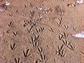
OMG! RAPTOR TRACKS!
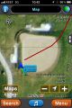
Map
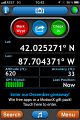
GPS
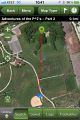
Hey look! A geocache nearby!

It's way back there!
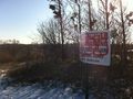
Top of the sled hill
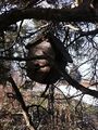
The cache is a fake bird house
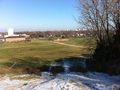
Hashpoint from the top of the sled hill


Achievements
RocketMac earned the Land geohash achievement
|
RocketMac earned the Hash collision honorable mention
|
RocketMac earned the Raptor Evasion Achievement
|
RocketMac achieved level 4 of the Minesweeper Geohash achievement
|