2011-12-23 47 9
| Fri 23 Dec 2011 in Sankt Gallen: 47.7899611, 9.0375325 geohashing.info google osm bing/os kml crox |
Location
Today's location is in a forest at the Bodensee. It is near the town Bodman which gave the lake its name in many languages. Except for English and a few other languages, in which the name Lake Constance is taken from the city of Konstanz.
Country: Germany; state: Baden-Württemberg (EU:DE:BW); administrative region: Freiburg; district: Konstanz
Plans
Leave the B33 road, go to Bodman, walk to the hashpoint without getting lost, return to B33 and continue to Konstanz.
Note: This plan is already bad, since the Autobahn A98 has an exit very near Bodman and much of the detours could have been avoided easily, if I had just taken a better look at the map. Or used my navigation system.
Expedition
Danatar
By the time I reached the 47 9 graticule it was already dark. I didn't pay attention at the Autobahn cloverleaf Hegau and found myself on the Autobahn in south-western direction, to Schaffhausen. I turned 2 exits later and finally was on the B33 road as planned. Not much later I missed the exit to Radolfzell and to the B34 road to Bodman. The next road in the correct direction that I had on my map just went under my road without an exit. I finally reached the road to Markelfingen, took a few looks at my map and drove along small country roads via Markelfingen, the outskirts of Radolfzell and Liggeringen to Bodman. After Markelfingen, I suddenly saw a red flash on the side of the road in front of me. Oh, speed trap. Apparently the road I was driving on still counted as within town limits and I was driving faster than allowed.
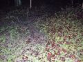
There I parked my car at the edge of the forest and walked along a small dirt track towards the hashpoint. It was very dark and I had only a small electric torch with me, I navigated by following the small lines on my GPS unit which indicated tracks. After 150 metres I found a signpost with directions for varous hiking roads, but none of them was marked as "to the hashpoint". A few steps later I found myself in the forest, next to a steep incline. On top of that incline I could see the lights of a building. The track that was shown by my GPS unit and that should lead by that building was not visible. I tried another track, but while walking across a dark meadow I felt mud and water under (and sometimes over) my feet. At that point I decided that I would not try further for the hashpoint: It was dark, my feet were getting wet and dirty, I had no idea where those tracks were supposed to be, I didn't want to get lost in such an environment and my family was waiting for me. I turned back to the car and used my navigation system to get to Konstanz.
Aftermath: 4 weeks after the expedition, the letter with the speeding ticket arrived. I had been expecting it, because from a quick glance at the speedometer I knew I had been driving a bit above 60 km/h and so I was expecting a small fine of 25 €. But the letter came with a bad surprise: Apparently the road (wide, straight, no intersections) didn't have the standard speed limit of 50 km/h, but 40 km/h (25 mph). I had been caught at 61 km/h (38 mph), 21 km/h above the limit. The fine was 80 € for misdemeanor + 20 € procedural costs + 3.50 € for stamps, so a total of 103.50 € ($ 136 with today's exchange rate). I also received my first mark in the Central Register of Traffic Offenders.
No, I don't want to continue here, I'm leaving.
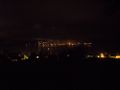
the western tip of the Bodensee (Lake Constance), seen from above Bodman.

