2011-12-31 42 -87
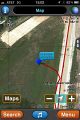
| Sat 31 Dec 2011 in 42,-87: 42.9315669, -87.9365828 geohashing.info google osm bing/os kml crox |
Contents
[hide]Location
A patch of land in the North/West corner of an interchange where the NE and SW corners have park-and-ride lots.
Participants
Plans
RocketMac
I saw that the New Year's Eve and New Year's Day hashpoints for this graticule were easy to get to and only a few miles, so I had to try for a Consecutive Geohash Achievement
Reschultzed
I was thinking the same thing as RocketMac. Weird.
Expedition
RocketMac
I was worried about getting to this one from the maps. Could I walk around the construction in Street View? If construction was over would there be barriers? What was on that land now?
Turns out, it's a large rain reservoir.
I drove down and considered just pulling over on the ramp to get the pictures, but I was worried about unwanted attention for pulling over on a ramp. Instead I opted for my original plan which was the South-East park-and-ride. That side has a fence, so I had to walk back to the intersection and then back down the ramp to get to the hashpoint.
Due to the recent rain, there were some soggy spots, but I was able to plot a (mostly) dry route from the ramp to the hashpoint and back out again.
Because the reservoir is low, I was no longer able to see the two or three nearby hotels from the point. I was considering stopping at one for a Pub Geohash while I was at it. Ah, well.
Reschultzed
The closest I got was the offramp itself on the way home from Lake Park. I brought my parents, sister, and dog to the (approximate) hashpoint.
Tracklog
My log is available in GPX and KMZ formats
Photos
RocketMac

That's a matter of opinion...
GPS
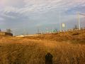
Looking up from the hashpoint
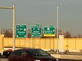
For all your parking needs
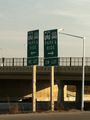
Freeway signs


Reschultzed


Achievements
RocketMac earned the Land geohash achievement
|