2012-01-07 -38 145
| Sat 7 Jan 2012 in -38,145: -38.4703656, 145.4493502 geohashing.info google osm bing/os kml crox |
Contents
[hide]Location
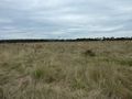
In a field off the Bass Highway near Coronet Bay
Who went
- Felix Dance and Sasha, who stayed in the car.
Expedition
Felix Dance
Sasha and I were heading back from Inverloch to Melbourne, when, before we left, we discovered this interesting geohash along the way. Just off the Bass Highway and only 150m from the road, on what looked like an empty field I loaded up the coords, grabbed my camera and we headed off.
Remembering to check the GPS just as we were luckily nearing the hash (rather than heading away from it), we drove down a small road to our left that looked like it was heading towards the hash. Whoops! The road looped back onto the Bass Highway.
Soon we found the correct Soldier's Road and were driving down it towards the hash. Sasha chose to stay in the car as I jumped over the barbed and electrified fence and marched resolutely towards the hash point in a way particular to trespassing geohashes preferring not to encounter a field's owner.
The grass was quite long, so I was worried about snakes, and it didn't help that a rabbit leapt out from a warren under my foot at one point. After getting to the hash, taking the obligatory GPS, Felix and surrounds photos, I was heading back. This time, I found it quite tricky to negotiate the barbed and electrified fence, the electric part of it being on my side this time so I couldn't jump it from a post. I ended up clambouring around amongst a pack of grass-straddling spiders to get out. The cows in the next field looked at my confusedly.
But then I was out and Sasha and I were continuing our journey to Melbourne.
Here is the Google Maps route we took.
Photos
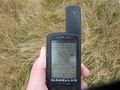
GPS proof

Felix with haircut at the hash
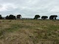
East view
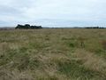
North view
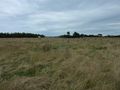
West view
South view


