2012-01-19 55 13
| Thu 19 Jan 2012 in 55,13: 55.9492864, 13.5292310 geohashing.info google osm bing/os kml crox |
Location
Ekastiga, northwest of Höör, Skåne, Sweden.
Participants
Plans
Drive by and walk out to see if it accessible.
Expedition
I knew this place from before. I had stopped by and walked through the forest to log a nearby cache, 163 meters from the geohash at 2012-04-06. I didn't bother to look up the geocache again but I took a photo showing the hunting tower standing on the ground in spring, and now was fully erected. Since I knew the place I could this time drive all the way except the last 100 meters to the geohash. The last time I spotted a roedeer just about the geohash location, but this time I didn't see any. I don't know if this geohash grants me the right of a Déjà vu achievement, but it is the closest one yet for me. I traced the road back and added it to Openstreetmap later since this one haven't been mapped yet.
Photos

Proof

The grin
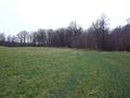
North
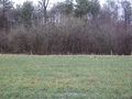
East
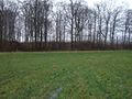
South
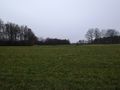
West
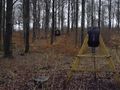
Hunting tower today
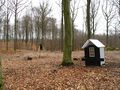
Photo taken at 2011-04-06 just about 110 meters from geohash
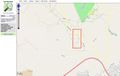
Tractor road added to OSM


Achievements
Llavids earned the Land geohash achievement
|
Llavids earned the OpenStreetMap achievement
|