2012-02-15 59 18

| Wed 15 Feb 2012 in 59,18: 59.3913995, 18.2753530 geohashing.info google osm bing/os kml crox |
Location
In a snowy horse paddock near Vaxholm.
Participants
Plans
This one looked so easy, only 16 km from the home (as the crow flies). I can bike that easily. Leave at 13:00, reach it by 15:00, back by 17:00.
Expedition
My first bike hash, close enough to my home I thought. It was just above freezing when I set off since it had been snowing the day before and the cloud cover had heated everything so the snow should have melted on all bike paths I thought. So I got on 4 layers of clothes and pumped the tires and used and allen-key to reattach one of the pedals which was a bit loose from before.
Not true. Sure inside the city it was just a tiny bit of brown slush on the ground. But as soon as I reached Norrtull they were building and I had to to a detour north and then the snow started covering the ground. They had plowed the bike paths but not salted them so there was 2-3 cm of compacted snow with footprints and bike tracks so both wheels started to slide around a bit sideways continuously so you had to be on your toes all the time and the speed dropped.
I wasn't cold and all the way up to Danderyds Hospital the bike paths were ok but as soon as i started following the Roslagbanan train lines there was more snow, more compacted with semi loose snow on top so I couldn't stand up and pedal cause then the back wheel would loose traction. I continued past Djursholms Ösby and started biking in the road instead since the cars had melted away the snow so I could progress a bit faster. Once the road ended and I had to go on the bike paths again my speed dropped considerably. And now it started snowing as well. I passed a girl on her bike on the way home from school on a hill and she was walking next to her bike complaining aloud her crappy bike that didn't work in these conditions. The pike paths weren't perfectly marked and I had to stop quit often and consult the map in my phone. Got to Täby centrum and they were building like crazy so onto temporary walk paths with a lot of slush.

After Täby the bike paths took twisty turns that weren't easy to follow. And as I got closer to the road towards Vaxholm I missed a left turn and started following the wrong path. I realized my mistake when I ended up by the shore, an unexpected body of water. I back tracked and found the right turn that took me over the train lines and of course the signs were only visible when you came from the wrong direction. As I got to Arninge and the turn off towards Vaxholm I found a Max Hamburger joint. By now I had biked around 23 km and had some pain in my calf muscles and my buttocks were really sore. So I went into Max and had a burger and some water and warmed up a bit.

Then out in the snow again. Turns out that the "bike path" towards Vaxholm was just bike along the shoulder of a 90 km/h road which was cleared of snow except for on the shoulder where there was partly compacted, party slushy snow so I had to ride very close to the cars which passed very close to me and very quickly. Worst was a bus that was just 1 m from me when he passed. Since my calf muscles were starting to tire a lot and almost cramped up I had to go to lower gears and increase my cadence and tighten my clips so I could get a really even delivery of power and conserve my strength. I got to Pålsundsvägen and this road was all compacted snow with some tracks a bit cleared by the cars. The few cars there were passed me very cleany, but that wasn't the hard part. The hard part was the murderous hills the road went over.
Sometimes I just had to get of the bike and walk a bit to get some blood back into my muscles and stretch out a bit. My arms and hands were hurting by this stage as well. And in the down hill sections I couldn't go full speed since I was afraid of sliding the front wheel. One more murderous hill and now I was getting close. As I arrived I saw the horse paddock the hash was located in. About 15 cm of snow but no horses in the field so I figured I could just walk into it after I had ducked under the electrified fence. Found the hash and marked it by stamping down the snow and took some pics.
- Biked in the snow. -- Carl-Johan @59.3915,18.2753 16:11, 15 February 2012 (CET)

By now the sun was starting to set. Walked back in my own tracks to the bike and and started going homewards. Now I had a bit of a headwind and I had 14.7 km back to the warmth of Max Hamburgers in Arninge, which was the closest real civilization. I could keep an average speed of around 13 km/h so it would be a long time before I got back to Stockholm. As I got back on the 90 km/h road I started riding almost out in the car lane to keep away from the slush on the shoulder. This had the effect on the cars that they actually slowed down a bit when they passed and they gave me more room. By now it was dark and it was snowing and I had a headwind. I had to stop every 2 km and get some blood back into my muscles and stretch a bit. My toes were getting cold from being cramped into my tight clips. And they were a bit damp from all the snow in the field. I soldiered on to Max in Arninge.
I bought a Low Carb meal and to my surprise a burger with a huge salad leaf instead of a bun was really good. I called some relatives that live in Täby cause by now I was really tired and my ass was hurting from this long 50 km bike ride. My Dad's cousin Lennart was home and he had just returned home from a trip to China so I figured 5-6 more km and I could be having a nice cup of tea at his place, so back on the bike. By now my hands were freezing and my toes were super numb. I got to his place in Täby Centrum after a 55.7 km journey and as promised I got my cup of Chinese tea and I could dry my clothes a bit. My dad arrived in my car and all three of us talked memories and genealogy and then I drove my dad home in my car and headed home.
A true adventure in the snow, but I made it. I'll be in pain tomorrow though I think.
Tracklog
- You can view the whole trip here google maps.
I also did some MyTracks experiments on the way back from the hash.
Photos
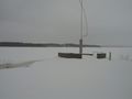
Obviously made a wrong turn, that is the Baltic.
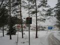
Only 10 km to go (actually 14.7), but that Burger place looks nice.
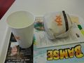
Mmmm, Burger.
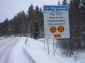
Won't be a problem, hash is 5km from this point.
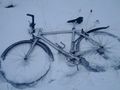
Trusty bike
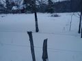
Lets hope those wires aren't live.
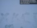
Snow @59.3914,18.2753
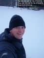
Grin @59.3914,18.2753


Achievements
Carl-Johan earned the Land geohash achievement
|
Carl-Johan earned the Bicycle geohash achievement
|