2012-02-26 47 7
| Sun 26 Feb 2012 in 47,7: 47.0000466, 7.4837187 geohashing.info google osm bing/os kml crox |
Contents
[hide]Location
The geohash is inside a forest not far from Berne.
Who Went
TheOneRing - by bike public transport.
The Expedition
TheOneRing
The weather was forecasted to be good, the spring is coming and as I haven't been geohashing for the last two months I really wanted to go. The geohash was located approximately 12km North of Berne in a forest next to an autobahn.
So far the plan, but one tire was flat, even the weather forecast was better then the real weather. So, I took a train and walked through the forest. I didn't print a map so I had to rely on my GPS, which was fun. Anytime it was like "hmmm, the trail goes right, but the GPS says left ... hmmm, GPS must be right, let's go left".
The way through the forest varied from snow-covered to green and muddy. Near the geohash the path got really icy, muddy and wet, so it was a final challenge ;) After reaching the geohash I made a short rest and took the usual photographs. It lied on a hillsides and On the way back I took a different route and finally another train to Berne.
Photos
TheOneRing
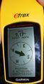
Exactly here...
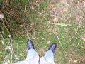
...in a muddy field was the geohash
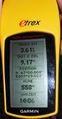
Some additional information

A happy hasher
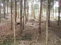
The hillside where the geohash was


Achievements
TheOneRing earned the Land geohash achievement
|
TheOneRing earned the Public transport geohash achievement
|