2012-03-03 47 10
| Sat 3 Mar 2012 in Kempten: 47.3299215, 10.8193385 geohashing.info google osm bing/os kml crox |
Location
Today's location is near the village Nassereith, not far from the "Fernpassstraße" (Fernpass route). The [[wikipedia:Fern Pass|Fern Pass is one of the main mountain passes in this part of the Alps and the Fernpass route is one of only a few ways for getting from Germany to Tyrol. In the skiing season, it's always very crowded, especially on Saturdays. We had been in a traffic jam for about an hour (for 5 kilometres) and we had been able to skip another 10 kilometres of that traffic jam.
Expedition
Danatar
Expedition is such a large word... I was on my way to skiing in the Ötz valley in Tyrol. The Fernpass route was the best way to get there from Würzburg. I knew that the hashpoint would be right next to the road, so I asked my friends to stop near the hashpoint.
We stopped at a gas station about 200 metres south of the hashpoint. I got out, crossed the road and walked into the trees that lined the road. The snow was up to my shins, but that didn't stop me. What stopped me was the creek that lay between me and the hashpoint.
It would have been possible to walk along the road to the next bridge, then back to the hashpoint. But I didn't want to walk along that road (which as I told before is a very busy one) and I didn't want to keep the others waiting. So I walked back to the car and we continued. The whole expedition took less than 5 minutes.
One week later, on our way back home, I took a few picturs of the area in passing.
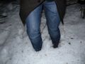
deep snow. Not in this picture: My new shoes...
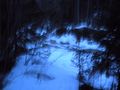
the creek, my trip ends here
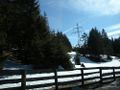
hash area seen from the northwest, you can see the powerlines in the satellite picture
the hashcreek in daylight


tracklog
You'll have to zoom very far to find the important part.