2012-03-03 59 17

| Sat 3 Mar 2012 in 59,17: 59.3299215, 17.8193385 geohashing.info google osm bing/os kml crox |
Location
2 km west of the Swedish Stazi in a clear cut part of the woods.
Participants
Plans
This was just to close to pass up. I thought about biking but I had all the stuff in my car anyway so in the end driving seemed easier.
Expedition
I am by law prohibited to describe what I saw 2 km east of the hash. Look on google maps or OSM to see what they call the Swedish Stazi.
After passing the secret place google maps took me on a route that I'm not sure is optimal. It isn't the first time it has taken me on routes that turn into roads you can't legally drive on. As I got close to the shore of this island I got to another protected site, a water treatment plant. Two skaters were on the ice just by the poles in the water fencing of the area. I eventually hit the "no more driving" sign and parked the car and started walking. Walked around the water treatment plant and onto a gravel road.
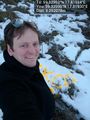
I was a beautiful spring day and a lot of people walking here. i turned off the road into a clear cut south of it. It was the first time i didn't have my Icebug shoes on and the paths here were frozen so it was very slippery. Found the spot and tried out my new Orange™ which was a bit more yellow, but supposedly this one dries faster and better och weird surfaces.

- Stazi is close -- Carl-Johan @59.3299,17.8193 16:01, 03 March 2012 (CET)
Snapped some pics and returned to the car. I took a more direct route home to the city.
Tracklog
Photos
Prohibited by law to photograph or describe the object @59.3316,17.8568
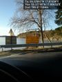
No diving @59.3278,17.8061
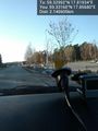
End of line for cars @59.3288,17.8097
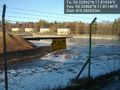
Water treatment plant. Put LSD in there. @59.3286,17.8114
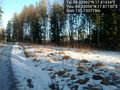
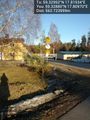
Over there @59.3305,17.8173
Made it @59.3299,17.8193
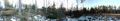
Panorama 1 @59.3301,17.8197

Panorama 2 @59.3306,17.8178
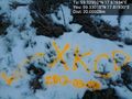
New Orange™ marker @59.3301,17.8193


Achievements
Carl-Johan earned the Land geohash achievement
|