2012-03-16 -37 145
| Fri 16 Mar 2012 in -37,145: -37.9029366, 145.1530995 geohashing.info google osm bing/os kml crox |
Location
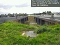
Between two lanes of Monash Freeway, where it passes over Ferntree Gully Rd.
Participants
Expedition
Like most of my solo geohashes, this one started with a tip-off from Felix Dance. "Guys, guys!" he wrote.
Anyway, it looked like an intriguing spot: between two lanes of a freeway, but accessible without crossing either of them. Curious. It was 3 in the afternoon, and I'd been working hard all day from home (and up late the night before too), so I didn't feel too guilty about taking a break to drive out there.
Parking at an abandoned (or dormant?) Vicroads project office, I wandered through relics of urban decay like rotting carpet, old signs, dumped computers and masses of broken glass. I scrambled up underneath the overpass, trying pathetically to remember how to get the GPS to show the direction to the hash. (How quickly you forget when a newer, sexier technology like a smartphone comes along...)
At the top of the slope (I'm sure Felix knows the technical words for all the bits of bridge, overpass etc...) there was a short fence, making it a proper geohash. I hopped over, and immediately became so distracted with all the technology in my hands that I became completely oblivious to the masses of traffic swirling in all directions. It was actually a pretty surreal spot: the city in the distance, cars and trucks on both sides and beneath me, but somehow very peaceful too. I clicked and clacked and tapped and swiped, then made like a shepherd and got the flock out of there.
Photos
Success! @-37.9028,145.1529
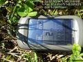
Proof.

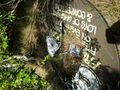
Urban decay.
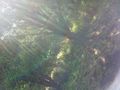
Creepy urban jungle.
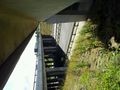
Comfy spot under the overpass.

Post-hash coffee art.


