2012-03-17 49 8
| Sat 17 Mar 2012 in 49,8: 49.9936191, 8.0928919 geohashing.info google osm bing/os kml crox |
Location
Between Heidesheim and Ingelheim, next to on-ramp “Ingelheim Ost”.
Participants
Plans
Take the train to Heidesheim, go to the hash point with my trusty Brompton folding bike and then bike back to Mainz along the river rhine.
Expedition
I set off at Eberstadt with the tram and went to Darmstadt Hbf. From there with the train to Mainz and then onwards to Heidesheim. I biked to the hash point, which was easy to find as it was right next to the road. I added a marker from activegeohasher.com to the guard railing and flew my kite within sight of the hash point (I wouldn't have wanted to fly it directly at the hash point, as there was a not-terribly-unbusy road right next to it). I considered going for the picnic achievement as I came prepared, but did I mention the hash point was right next to a road and not really all that nice? So I decided to take the Brompton and bike to the rhine and do the picnic there. I had it next to the village of Heidenfahrt with a nice view of the rhine. Afterwards, I biked back to Mainz, had some ice-cream on the way (it was quite a nice and sunny day) and went back with the train to Eberstadt and by bike to my place.
Tracklog
On everytrail.com.
Photos
Setting of at tram stop Eberstadt Kirche

Hash point with marker, on-ramp in the background

The internet was here and attached dead tree with Gaffer tape
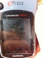
Proof (do I need to change the anti-scratch foil?)

Obligatory stupid grin

Flying a low-wind kite in medium wind

Up, up in the air

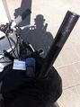
Bike parking near the hash point

Snakes on a plane, ehm, cars on a train
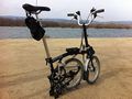
Brompton parking near the rhine
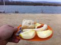
Picnic


Achievements
alech earned the Land geohash achievement
|
alech earned the Fly a kite achievement
|
alech earned the Public transport geohash achievement
|