2012-03-21 34 -83
| Wed 21 Mar 2012 in 34,-83: 34.3526419, -83.6082431 geohashing.info google osm bing/os kml crox |
Location
The hash was located about a mile down an old dirt road, and a quarter mile into the woods after that.
It was a very redneck Appalachian sorta place, and the entire woods was littered with old structures and metal heaps and refrigerators and trash. The spot itself was marked by an old wooden ladder (in pic below).
Participants
Plans
I had two hours between college classes, and I estimated the hash to be about 53 minutes away (plus a short walk through the woods). I didn't plan ahead at all, I just headed out impulsively. I made it to my next class on time, too, believe it or not!
Expedition
I came home after class, and I got online and checked the coordinates. I asked my brother to find his old GPS, which he grudgingly did. And then I rode off into the blue. It wasn't any more complicated than that! And the spot was wonderfully easy to find. It was a beautiful ride out, and I'm looking forward to being able to do this more often.
And also this is my first geohash
so if I screwed something up please forgive me
Photos
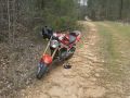
This is my bike, The Baron, parked where I ran out of road and had to continue on foot.
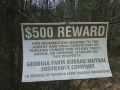
I did not do any of the things on this sign.
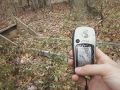
The closest my GPS got was 8 feet away, as is evidenced here. GPS has a 20-foot uncertainty radius, so I trampled around the woods for a while to make sure that wherever the point was, I was at it.
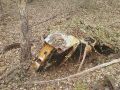
I met this sweet ride on the way back through the woods.


Achievements
- Land Geohash